Home
Weather London
WeatherRadar
RainfallRadar
TemperatureRadar
WindRadar
LightningRadar
Weather News
Editor's Pick
Discover the app
Weather widget
Contact us
Apps
Career
    Home / Editor's Pick /

    Major incident declared: Flood warnings as heavy rain returns

15:00
4 January 2024

Major incident declared
Flood warnings as heavy rain returns

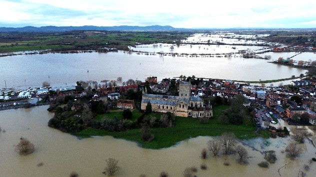
Abbey surrounded by flooded fields
Tewkesbury Abbey on Wednesday was surrounded by floodwater after days of heavy rainfall. - © picture alliance

Major flooding continues to break out across the United Kingdom, with weather and flood warnings in place as Nottinghamshire declares a major incident.

Heavy rain along the southern English coastline this afternoon and continued showers across much of the UK prompted around 500 flood warnings to be issued, primarily across England today.

Although not all areas see a return of torrential rainfall, which is largely confined to the south and south-east of England, many areas have seen soil saturated with rainfall from Storm Henk. Making repeated flooding from fresh rainfall more likely, even with lesser amounts.

A major incident has been declared by Nottinghamshire County Council as the River Trent approaches record high levels. Key tributaries, such as the River Derwent and River Dove, are already receding. However, the Trent itself is swelling, with high water levels running down the river increasingly making flooding likely.

The current record high for the Trent 5.5 m recorded in November 2000. In Worcester, flood barriers are being installed along the River Severn which is likely to peak on Friday morning with the potential to also set a record-high.

Elsewhere, Great Western Railway says that any commuters heading to Cornwall, Devon, Somerset, or Wiltshire today should travel as soon as possible with disruption to lines expected later today.

Privacy Policy

With weather warnings in place until the early hours of Friday, there may be more disruption ahead. Strong gusting winds begin to build again into the evening, strongest on the south coast. On the Channel Islands, gusts reaching up to 74 mph are likely.

Torrential rainfall is already falling across the southern coast, and will push north-east into East Anglia, brushing parts of the East Midlands, into the evening.

There is some potential for thunderstorms to develop, however it currently appears that these will be restricted offshore in the English Channel.

Follow events as they develop with the WeatherRadar and WindRadar.

Tips: Preparing for a floodread more
Weather & Radar editorial team
More on the topic
Half of England now in drought. Joining North Wales. . . Wednesday, 29 July 2026
Dry section of the River Thames beneath a small stone bridge, with the riverbed exposed and cracked after prolonged, dry weather, while a person walks along the roadside above.
Wednesday, 29 July 2026

Joining North Wales

Half of England now in drought
Icy spells in the Southern Hemisphere. Snow in the Andes. . . Tuesday, 28 July 2026
A composite image showing a temperature radar map of South America and a snow-covered town in Chile. The winter cold is bringing heavy snowfall to the Andes and, in some areas, snow down to lower altitudes.
Tuesday, 28 July 2026

Snow in the Andes

Icy spells in the Southern Hemisphere
Clouds return to capture the scene. Your weather - Your shots. . . Sunday, 26 July 2026
Waxing crescent Moon above vivid pink and magenta sunset clouds, with silhouetted trees along the horizon beneath a deepening blue twilight sky.
Sunday, 26 July 2026

Your weather - Your shots

Clouds return to capture the scene
All weather news
This might also interest you
Super Typhoon Bavi threatens Taiwan. Up to 1,000 mm of rain. . . Wednesday, 8 July 2026
The image shows an intense tropical cyclone over the western Pacific, east of Taiwan and the Philippines. The centre of the system is depicted as a light purple and white vortex with a clearly visible eye, surrounded by a ring of red and orange areas indicating the strongest wind speeds. A white arrow marks the typhoon’s predicted track towards the north-west, in the direction of Taiwan. To the west of the storm lie the Philippines, with the cities of Manila and Cebu; to the north of these lies Taiwan, with Taipei. Further west, the Chinese coast, including Hong Kong, and parts of Vietnam can be seen. The coloured wind map shows predominantly green areas outside the storm’s core, indicating significantly weaker winds. White streamlines illustrate the typhoon’s anti-clockwise circulation in the Northern Hemisphere. The highest wind speeds are concentrated around the eye of the cyclone.
Wednesday, 8 July 2026

Up to 1,000 mm of rain

Super Typhoon Bavi threatens Taiwan
Bright and warm conditions take hold. Spring-like outlook. . . Thursday, 23 April 2026
Split UK map showing warm temperatures up to 21 degrees in orange on the left and clear sunny conditions with temperatures from 12 to 18 degrees on the right, with sun icons across the country.
Thursday, 23 April 2026

Spring-like outlook

Bright and warm conditions take hold
Seasonal warmth between spring thunder. Your weather - Your shots. . . Sunday, 19 April 2026
Split image showing coastal sunset with layered lenticular clouds over rooftops and palm trees on the left, and a green valley with river and hills under soft daylight on the right.
Sunday, 19 April 2026

Your weather - Your shots

Seasonal warmth between spring thunder
All articles
Weather & Radar

Weather & Radar is also available on

Google Play StoreApp Store

Company

Contact us Privacy Policy Legal info Accessibility statement

Services

Uploader

Socials

facebooktwittertikToklinkList