Home
Weather London
WeatherRadar
RainfallRadar
TemperatureRadar
WindRadar
LightningRadar
Weather News
Editor's Pick
Discover the app
Weather widget
Contact us
Apps
Career
    Home / Editor's Pick /

    Main impacts in the north - Storm Floris named for Monday

10:09
1 August 2025

Main impacts in the north
Storm Floris named for Monday

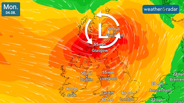
Wind map showing gales over the UK and Ireland, strongest in Scotland, in a forecast for Storm Floris.
Strong gales are set to arrive Monday with Floris.

Storm Floris has now been named, with expected impacts on Monday.

The system will sweep in overnight from Sunday into the start of the week. With gale-force winds accompanying heavy downpours.

Scotland and northern areas of the UK see the strongest impacts as Floris passes through the north. Unseasonable gales at this time of the year are likely to result in more damage compared to winter systems, with trees still in full leaf.

Gusts of 40 - 50 mph are likely across much of the northern UK while areas at higher elevation could see gusts of up to 70 mph.

The system is expected to ease from Monday night as Floris moves away into the North Sea.

Unstable weather due to jet stream
Ryan Hathaway
More on the topic
Split image showing a European weather map with low-pressyre system, temperature bands, and thunderstorm icon on the left, and a bright rainbow over green countryside and mountains on the right.
Wednesday, 27 May 2026

Early summer ends

A change in the weather is on the way
Temperature map of southeast England showing overnight low temperatures, with Kenley highlighted at 21.3°C and surrounding areas in yellow-orange shades indicating mild nighttime conditions.
Tuesday, 26 May 2026

May heatwave

Tropical night breaks overnight record
A composite image showing the Temperature Radar and a drinking fountain. The Temperature Radar shows Thursday’s maximum temperatures of up to 37.8 degrees in France, whilst people use a fountain to cool off.
Friday, 29 May 2026

Up to 38 °C in France

Heatwave clocks more record temperatures
All weather news
This might also interest you
Outline of Santa Claus with a yellow and white hat, "Ho-Ho-Ho" next to the outline above a Christmas tree.
Thursday, 25 December 2025

Merry Christmas!

Wishes from Weather & Radar
Split image showing a person in a yellow jacket struggling against strong winds and heavy rain on a street at night on the left, and an Irish wind forecast map on the right with red and purple shading, gusts up to 75 mph, and a wind warning icon, divided by a curved white line.
Saturday, 24 January 2026

On this day...

Historic Storm Éowyn arrives
Weather graphic showing rain and wind fields over the Canary Islands and a central warning symbol.
Friday, 12 December 2025

Storm and rain

Turbulent weather in the Canary Islands
All articles
Weather & Radar

Weather & Radar is also available on

Google Play StoreApp Store

Company

Contact us Privacy Policy Legal info Accessibility statement

Services

Uploader

Socials

facebooktwittertikToklinkList