Home
Weather London
WeatherRadar
RainfallRadar
TemperatureRadar
WindRadar
LightningRadar
Weather News
Editor's Pick
Discover the app
Weather widget
Contact us
Apps
Career
    Home / Editor's Pick /

    Low pressure influence - Stronger winds make a return

14:00
4 August 2026

Low pressure influence
Stronger winds make a return

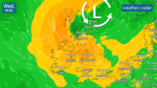
Wind forecast map of the UK and Ireland on Wednesday 05.08 showing a low-pressure system north of Scotland, with widespread winds of 25–40 mph across the British Isles. Strongest winds reach around 40 mph in Ireland and 35 mph across northern England, highlighted by airflow streamlines.
Stronger winds spread on Wednesday thanks to influence from a low-pressure system.

Gusting winds spread across parts of the UK and Ireland this week, with gusts potentially reaching up to 50 mph for some.

Stronger winds begin to build overnight into Wednesday as a low-pressure system moves from the west of Scotland to a position off the north-east coast.

By midday Wednesday, gusts of around 40 mph (65 km/h) are expected around the Irish Sea, possibly stronger in exposed coastal areas.

Later, similarly powerful gusts extend further, up to 45 mph in northern England and stronger still over higher ground including the Lake District and the North York Moors.

The blustery day ends with winds easing from the west as the responsible low continues its trajectory towards Norway, bringing its stronger gusts to Scandinavia and north-west Europe.

Have plans outdoors? Keep an eye on the WindRadar for the latest outlook, and the WeatherRadar for rainfall also falling.

Ryan Hathaway
More on the topic
More comfortable night's sleep. Overnight low drops. . . Wednesday, 5 August 2026
Morning temperature map of the UK and Ireland showing cool conditions, with temperatures ranging from 7°C in South Wales to 13°C in southeast England. Ireland records 9–12°C, while much of England and Wales is between 8°C and 10°C. A blue thermometer icon highlights the cooler weather.
Wednesday, 5 August 2026

Overnight low drops

More comfortable night's sleep
Solar eclipse on Wednesday. Save the date. . . Monday, 10 August 2026
People are watching a solar eclipse. The sun is already partially obscured. Next to it is the weather radar forecast for Wednesday, showing an almost cloudless sky.
Monday, 10 August 2026

Save the date

Solar eclipse on Wednesday
Late season views as summer rolls on. Your weather - Your shots. . . Sunday, 9 August 2026
Split image showing a horseback ride along a green hillside trail beneath blue skies on the left and a small sailboat on a calm coastal bay under broken clouds on the right.
Sunday, 9 August 2026

Your weather - Your shots

Late season views as summer rolls on
All weather news
This might also interest you
Turbulent weather in the Canary Islands. Storm and rain. . . Friday, 12 December 2025
Weather graphic showing rain and wind fields over the Canary Islands and a central warning symbol.
Friday, 12 December 2025

Storm and rain

Turbulent weather in the Canary Islands
Flooding, gales, and heavy snow. Storm Chandra. . . Tuesday, 27 January 2026
Split image showing aerial flooding in a town with muddy water covering roads on the left, and a rural road on the right blocked by heavy snowfall with vans stopped and a person walking in snow.
Tuesday, 27 January 2026

Storm Chandra

Flooding, gales, and heavy snow
Historic Storm Éowyn arrives. On this day.... . . Saturday, 24 January 2026
Split image showing a person in a yellow jacket struggling against strong winds and heavy rain on a street at night on the left, and an Irish wind forecast map on the right with red and purple shading, gusts up to 75 mph, and a wind warning icon, divided by a curved white line.
Saturday, 24 January 2026

On this day...

Historic Storm Éowyn arrives
All articles
Weather & Radar

Weather & Radar is also available on

Google Play StoreApp Store

Company

Contact us Privacy Policy Legal info Accessibility statement

Services

Uploader

Socials

facebooktwittertikToklinkList