Home
Weather London
WeatherRadar
RainfallRadar
TemperatureRadar
WindRadar
LightningRadar
Weather News
Editor's Pick
Discover the app
Weather widget
Contact us
Apps
Career
    Home / Editor's Pick /

    Lightning strikes in dry conditions - positive earth flashes

13:50
17 August 2026

Positive earth flashes
Lightning strikes in dry conditions

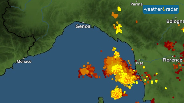
Severe thunderstorms developed around Genoa, Italy in recent days, with lightning strikes reaching the ground even away from the thunderclouds, an event known as positive ground flashes.

Positive ground flashes are relatively rare: only around 5 to 10% of all ground flashes are of this type. They usually originate high up in the thundercloud and can travel an astonishingly long distance from there.

For example, a bolt of lightning can strike many kilometres away from the actual thunderstorm – even in dry conditions. The images from the Gulf of Liguria near Genoa illustrate this impressively.

LightningRadar showing lightning strikes in the Gulf of Liguria.

This means that there may still be a risk of lightning, even if the storm clouds seem a distance away and there's no rain falling in the area. The LightningRadar shows at a glance recent strikes so you can stay alert to lighting around you.

Positive ground flashes are also dangerous because they can reach particularly high current levels. As a result, they are often significantly more powerful than ordinary negative ground flashes. They occur mainly during severe thunderstorms.

Weather & Radar editorial team

More on the topic

Autumn is the season for fog. High pressure, but no sun. . . Thursday, 5 November 2026
A split-screen image showing the weather radar for Europe and a mountain landscape. On the right, snow-capped peaks rise above a thick blanket of fog against a blue sky.
Thursday, 5 November 2026

High pressure, but no sun

Autumn is the season for fog
Conditions combine to reduce air quality. Light winds and fireworks. . . Tuesday, 10 November 2026
Split image showing a UK wind map with 25 mph near Cardiff and 19 mph near London, beside colourful fireworks above illuminated waterfront buildings.
Tuesday, 10 November 2026

Light winds and fireworks

Conditions combine to reduce air quality
Gloomy evening with a few spots of rain. Bonfire Night. . . Thursday, 5 November 2026
Split image showing a cloudy UK weather map with temperatures of 8–9°C alongside colourful fireworks bursting through smoke in the night sky.
Thursday, 5 November 2026

Bonfire Night

Gloomy evening with a few spots of rain
All weather news

This might also interest you

Flooding, gales, and heavy snow. Storm Chandra. . . Tuesday, 27 January 2026
Split image showing aerial flooding in a town with muddy water covering roads on the left, and a rural road on the right blocked by heavy snowfall with vans stopped and a person walking in snow.
Tuesday, 27 January 2026

Storm Chandra

Flooding, gales, and heavy snow
A frozen start to the weekend. Icy conditions. . . Friday, 13 February 2026
UK temperature map dated 14.02 showing widespread subzero values in blue shading, with readings such as −4 in Glasgow, −3 in Dublin, and −2 in London, alongside a blue thermometer icon.
Friday, 13 February 2026

Icy conditions

A frozen start to the weekend
New records for England and Wales. Broken again tomorrow?. . . Thursday, 25 June 2026
Temperature map of southwest Britain on 25.06 showing extreme heat across southern Wales and southwest England, with Bute Park in Cardiff highlighted at 34.2°C and Yeovilton at 36.4°C amid widespread deep red heat zones.
Thursday, 25 June 2026

Broken again tomorrow?

New records for England and Wales
All articles
Weather & Radar

Weather & Radar is also available on

Google Play StoreApp Store

Company

Contact us Privacy Policy Legal info Accessibility statement

Services

Uploader

Socials

facebooktwittertikToklinkList