Home
Weather London
WeatherRadar
RainfallRadar
TemperatureRadar
WindRadar
LightningRadar
Weather News
Editor's Pick
Discover the app
Weather widget
Contact us
Apps
Career
    Home / Editor's Pick /

    Lightning, hail, gales - Severe weather spreads across Europe

12:00
15 July 2026

Lightning, hail, gales
Severe weather spreads across Europe

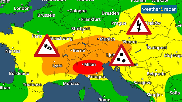
Much of Europe is once again facing the threat of severe thunderstorms today, as hot and humid air creates favourable conditions for intense storm development.

The areas most at risk extend from France across the Alps to Poland. Large hailstones, gale-force winds, and torrential rain are possible, particularly in northern Italy.

Severe weather warning map of central Europe showing colour-coded alert areas with warning symbols for strong winds over eastern France and western Switzerland, thunderstorms from Austria into southern Poland, and heavy rain across northern Italy and hte northern Adriatic.
Severe weather warnings are currently in place across large parts of Western and Central Europe.

As is often the case with such severe weather conditions, not every area will be affected. However, where particularly intense thunderstorms form, there is potential for massive damage caused by lightning strikes, gales, and flash-flooding.

Even brief tornadoes cannot be ruled out in such volatile weather conditions, with the greatest risk across northern Italy. As the WeatherRadar shows, thunderstorms have been active since this morning. However, conditions are expected to be at the most severe this afternoon and this evening.

Keep an eye on the situationWeatherRadar
Jürgen Vollmer
More on the topic
Severe weather rolls on in Europe. Heavy rain and hail. . . Thursday, 17 September 2026
Weather radar showing severe thunderstorms and frequent lightning over northern Italy.
Thursday, 17 September 2026

Heavy rain and hail

Severe weather rolls on in Europe
Colourful skies and scenic clouds cover. Your weather - Your shots. . . Sunday, 20 September 2026
Split image showing a golden sunset over the sea beneath layered clouds and a pink-purple sunset reflected across calm riverside water.
Sunday, 20 September 2026

Your weather - Your shots

Colourful skies and scenic clouds cover
Low delivers days of gusty conditions. Into the weekend. . . Thursday, 17 September 2026
Wind map showing low pressure near the Faroe Islands, with winds reaching 35 mph around Aberdeen and Dublin and stronger Atlantic winds west of the UK.
Thursday, 17 September 2026

Into the weekend

Low delivers days of gusty conditions
All weather news
This might also interest you
Super Typhoon Bavi threatens Taiwan. Up to 1,000 mm of rain. . . Wednesday, 8 July 2026
The image shows an intense tropical cyclone over the western Pacific, east of Taiwan and the Philippines. The centre of the system is depicted as a light purple and white vortex with a clearly visible eye, surrounded by a ring of red and orange areas indicating the strongest wind speeds. A white arrow marks the typhoon’s predicted track towards the north-west, in the direction of Taiwan. To the west of the storm lie the Philippines, with the cities of Manila and Cebu; to the north of these lies Taiwan, with Taipei. Further west, the Chinese coast, including Hong Kong, and parts of Vietnam can be seen. The coloured wind map shows predominantly green areas outside the storm’s core, indicating significantly weaker winds. White streamlines illustrate the typhoon’s anti-clockwise circulation in the Northern Hemisphere. The highest wind speeds are concentrated around the eye of the cyclone.
Wednesday, 8 July 2026

Up to 1,000 mm of rain

Super Typhoon Bavi threatens Taiwan
A frozen start to the weekend. Icy conditions. . . Friday, 13 February 2026
UK temperature map dated 14.02 showing widespread subzero values in blue shading, with readings such as −4 in Glasgow, −3 in Dublin, and −2 in London, alongside a blue thermometer icon.
Friday, 13 February 2026

Icy conditions

A frozen start to the weekend
Historic Storm Éowyn arrives. On this day.... . . Saturday, 24 January 2026
Split image showing a person in a yellow jacket struggling against strong winds and heavy rain on a street at night on the left, and an Irish wind forecast map on the right with red and purple shading, gusts up to 75 mph, and a wind warning icon, divided by a curved white line.
Saturday, 24 January 2026

On this day...

Historic Storm Éowyn arrives
All articles
Weather & Radar

Weather & Radar is also available on

Google Play StoreApp Store

Company

Contact us Privacy Policy Legal info Accessibility statement

Services

Uploader

Socials

facebooktwittertikToklinkList