Home
Weather London
WeatherRadar
RainfallRadar
TemperatureRadar
WindRadar
LightningRadar
Weather News
Editor's Pick
Discover the app
Weather widget
Contact us
Apps
Career
    Home / Editor's Pick /

    Large storms in Europe: How to track thunderstorms in the app

11:00
3 June 2023

Large storms in Europe
How to track thunderstorms in the app

Lightning maps
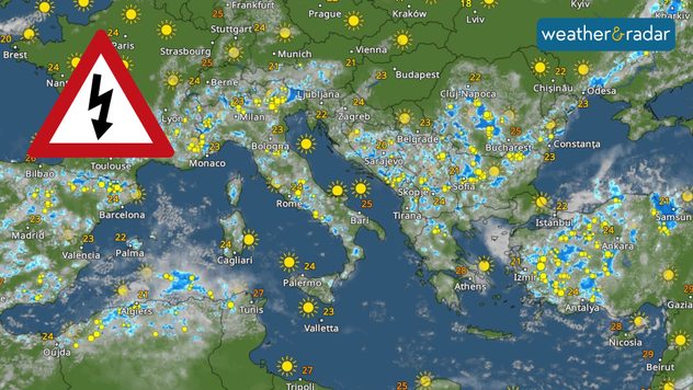
Thunderstorms are active across Europe, shown on the WeatherRadar.

Thunderstorms are spreading across Europe. Here's how to spot them and track them live on our LightningRadar.

Our WeatherRadar is the quickest and best way to see whether one is headed your way. Here, thunderstorms are displayed as yellow dots.

When you press the play button or toggle the bar you will see the path of the thunderstorms.

For a live view of the strikes, we also have our LightningRadar. Here you can watch in real-time as the lightnings strike.

New lightning strikes are indicated with an expanding ring. The most recent lightning strikes have a red border that will slowly fade to different shades of yellow as they age, helping you determine where the most recent ones are happening!

The strikes are visible for 15 minutes in this live view. But to get a better visual of what each coloured dot means, simply click the information icon on the LightningRadar to view the legend.

Try it now and watch the storms unfold!

Weather & Radar editorial team
More on the topic
Fourth heatwave of the year. Peaking Wednesday. . . Tuesday, 28 July 2026
Temperature map of England and Wales on Wednesday 29.07 showing widespread hot conditions, with temperatures reaching 33°C near Cambridge, 32°C around London, Norwich, and Southend-on-Sea, and a large heat warning symbol highlighting elevated heat risk.
Tuesday, 28 July 2026

Peaking Wednesday

Fourth heatwave of the year
Catastrophic forest fires in Europe. Thousands evacuated. . . Monday, 27 July 2026
A composite image showing a temperature map of south-western Europe and a drone shot of a forest fire near Cap Ferret. A warning symbol featuring a flame indicates the increased risk of forest fires.
Monday, 27 July 2026

Thousands evacuated

Catastrophic forest fires in Europe
Clouds return to capture the scene. Your weather - Your shots. . . Sunday, 26 July 2026
Waxing crescent Moon above vivid pink and magenta sunset clouds, with silhouetted trees along the horizon beneath a deepening blue twilight sky.
Sunday, 26 July 2026

Your weather - Your shots

Clouds return to capture the scene
All weather news
This might also interest you
Storm Chandra makes impact. Severe gales & heavy rain. . . Tuesday, 27 January 2026
Split image showing strong winds over the UK on a forecast map and widespread rain and snow on a weather radar map.
Tuesday, 27 January 2026

Severe gales & heavy rain

Storm Chandra makes impact
Historic Storm Éowyn arrives. On this day.... . . Saturday, 24 January 2026
Split image showing a person in a yellow jacket struggling against strong winds and heavy rain on a street at night on the left, and an Irish wind forecast map on the right with red and purple shading, gusts up to 75 mph, and a wind warning icon, divided by a curved white line.
Saturday, 24 January 2026

On this day...

Historic Storm Éowyn arrives
Bright and warm conditions take hold. Spring-like outlook. . . Thursday, 23 April 2026
Split UK map showing warm temperatures up to 21 degrees in orange on the left and clear sunny conditions with temperatures from 12 to 18 degrees on the right, with sun icons across the country.
Thursday, 23 April 2026

Spring-like outlook

Bright and warm conditions take hold
All articles
Weather & Radar

Weather & Radar is also available on

Google Play StoreApp Store

Company

Contact us Privacy Policy Legal info Accessibility statement

Services

Uploader

Socials

facebooktwittertikToklinkList