Home
Weather London
WeatherRadar
RainfallRadar
TemperatureRadar
WindRadar
LightningRadar
Weather News
Editor's Pick
Discover the app
Weather widget
Contact us
Apps
Career
    Home / Editor's Pick /

    Lapland ice chamber – Temperatures drop below -40 °C

10:37
13 January 2026

Lapland ice chamber
Temperatures drop below -40 °C

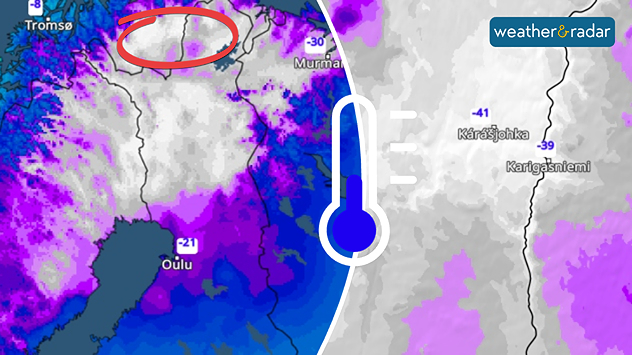
Extreme temperatures of below minus 40 degrees were recorded in Lapland over the weekend.

With lows of below -15 °C in some places, parts of Central Europe experienced the coldest nights of this winter over the weekend. It was even colder in Lapland, with lows below -40 °C recorded.

Scandinavia's lowest temperaturesread also

The coldest temperatures were recorded on Sunday in Karasjok in Finnmark, northern Norway, where the mercury dropped to minus 41.5 degrees early on Sunday morning.

Thousands of travellers were stranded in nearby Kittilä after the airport had to be completely closed due to the persistent cold.

However, the icy cold is now also receding in Lapland: it will become increasingly milder in the coming days, and only light to moderate frost is expected at the weekend – at least temporarily.

Karasjok

We
15
19
Th
12
21
Fr
11
19
Sa
15
16
Su
7
18
Mo
5
15
Tu
8
15
We
8
15
Th
7
15
Fr
8
15
Sa
7
15
Su
7
15
Mo
7
15
Tu
6
15
Max (°C)
Min (°C)
moreless
Jürgen Vollmer
More on the topic
Rain returns to end dry spell in places. Jet stream delivery. . . Thursday, 23 July 2026
Split weather graphic showing widespread showers across the UK and Ireland on the left, and a wind forecast map on the right with a windsock icon and gusts of 25 to 35 mph, highlighting breezy conditions across the two countries.
Thursday, 23 July 2026

Jet stream delivery

Rain returns to end dry spell in places
Fourth heatwave of the year. Peaking Wednesday. . . Tuesday, 28 July 2026
Temperature map of England and Wales on Wednesday 29.07 showing widespread hot conditions, with temperatures reaching 33°C near Cambridge, 32°C around London, Norwich, and Southend-on-Sea, and a large heat warning symbol highlighting elevated heat risk.
Tuesday, 28 July 2026

Peaking Wednesday

Fourth heatwave of the year
Drought for North Wales and Upper Severn. 2% of average rainfall. . . Thursday, 23 July 2026
Split image showing a July rainfall anomaly map of Europe on the left with below-average rainfall across the UK, Ireland, and much of western and central Europe, and an active moorland wildfire on the right producing flames and thick smoke near homes.
Thursday, 23 July 2026

2% of average rainfall

Drought for North Wales and Upper Severn
All weather news
This might also interest you
Flooding, gales, and heavy snow. Storm Chandra. . . Tuesday, 27 January 2026
Split image showing aerial flooding in a town with muddy water covering roads on the left, and a rural road on the right blocked by heavy snowfall with vans stopped and a person walking in snow.
Tuesday, 27 January 2026

Storm Chandra

Flooding, gales, and heavy snow
A frozen start to the weekend. Icy conditions. . . Friday, 13 February 2026
UK temperature map dated 14.02 showing widespread subzero values in blue shading, with readings such as −4 in Glasgow, −3 in Dublin, and −2 in London, alongside a blue thermometer icon.
Friday, 13 February 2026

Icy conditions

A frozen start to the weekend
Seasonal warmth between spring thunder. Your weather - Your shots. . . Sunday, 19 April 2026
Split image showing coastal sunset with layered lenticular clouds over rooftops and palm trees on the left, and a green valley with river and hills under soft daylight on the right.
Sunday, 19 April 2026

Your weather - Your shots

Seasonal warmth between spring thunder
All articles
Weather & Radar

Weather & Radar is also available on

Google Play StoreApp Store

Company

Contact us Privacy Policy Legal info Accessibility statement

Services

Uploader

Socials

facebooktwittertikToklinkList