Home
Weather London
WeatherRadar
RainfallRadar
TemperatureRadar
WindRadar
LightningRadar
Weather News
Editor's Pick
Discover the app
Weather widget
Contact us
Apps
Career
    Home / Editor's Pick /

    Lake effect phenomenon: Heavy snow showers in northern USA

12:52
28 November 2025

Lake effect phenomenon
Heavy snow showers in northern USA

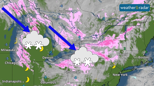
WeatherRadar: A cold north-westerly wind is picking up moisture over the Great Lakes, resulting in distinct "snow streets".

An interesting weather phenomenon is currently occurring on the Great Lakes in the northern United States this Thanksgiving.

Heavy snow showers are repeatedly sweeping across the eastern shores of the lakes, sometimes accompanied by winter storms with gusts of wind.

They can leave behind large amounts of snow in just a few hours, as this video from Michigan shows. The cause of the heavy snowfall is the so-called lake effect.

Privacy Policy

This phenomenon requires a strong cold wind that travels a long way over comparatively warm water, creating a large temperature contrast with the cold air above.

Resulting in heavy showers, one after the other. For the snow to remain on the ground, temperatures at ground level must be around or below 0 degrees.

Strong winds around the Great LakesGusts of wind also present

Tommy Kühnlein
More on the topic
Autumn arrives with vivid colour. Your weather - Your shots. . . Sunday, 6 September 2026
Split image showing peach-lit textured clouds above silhouetted trees and golden cumulus clouds reflected in a calm canal lined with boats.
Sunday, 6 September 2026

Your weather - Your shots

Autumn arrives with vivid colour
Hurricane Lowell threatens Hawaii. Gales and flash floods. . . Tuesday, 8 September 2026
WindRadar showing Hurricane Lowell north-west of Hawaii and its well-defined storm centre.
Tuesday, 8 September 2026

Gales and flash floods

Hurricane Lowell threatens Hawaii
Hottest summer on record for Ireland. Beating 2025's record. . . Thursday, 3 September 2026
Temperature map of Ireland showing 29°C in Dublin, 26°C in Cork, 24°C in Belfast, and 23°C in Galway, with a red thermometer icon.
Thursday, 3 September 2026

Beating 2025's record

Hottest summer on record for Ireland
All weather news
This might also interest you
Storm Chandra makes impact. Severe gales & heavy rain. . . Tuesday, 27 January 2026
Split image showing strong winds over the UK on a forecast map and widespread rain and snow on a weather radar map.
Tuesday, 27 January 2026

Severe gales & heavy rain

Storm Chandra makes impact
A frozen start to the weekend. Icy conditions. . . Friday, 13 February 2026
UK temperature map dated 14.02 showing widespread subzero values in blue shading, with readings such as −4 in Glasgow, −3 in Dublin, and −2 in London, alongside a blue thermometer icon.
Friday, 13 February 2026

Icy conditions

A frozen start to the weekend
Bright and warm conditions take hold. Spring-like outlook. . . Thursday, 23 April 2026
Split UK map showing warm temperatures up to 21 degrees in orange on the left and clear sunny conditions with temperatures from 12 to 18 degrees on the right, with sun icons across the country.
Thursday, 23 April 2026

Spring-like outlook

Bright and warm conditions take hold
All articles
Weather & Radar

Weather & Radar is also available on

Google Play StoreApp Store

Company

Contact us Privacy Policy Legal info Accessibility statement

Services

Uploader

Socials

facebooktwittertikToklinkList