Home
Weather London
WeatherRadar
RainfallRadar
TemperatureRadar
WindRadar
LightningRadar
Weather News
Editor's Pick
Discover the app
Weather widget
Contact us
Apps
Career
    Home / Editor's Pick /

    Jet stream delivery - Rain returns to end dry spell in places

09:00
23 July 2026

Jet stream delivery
Rain returns to end dry spell in places

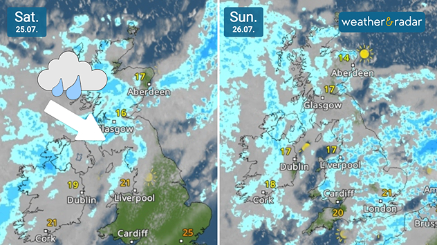
Split weather radars comparing Saturday 25.07 and Sunday 26.07 across the UK and Ireland. Saturday shows rain moving southeast across Scotland with an arrow indicating its direction, while Sunday brings widespread showers across the UK and Ireland.
A welcome sight for many on the WeatherRadar.

While parts of England are perilously close to drought, there is some relief on the way with a return of more widespread rain for the first time in a month for some.

High pressure has been dominating summer, keeping Atlantic systems at bay. This weekend, a weak frontal system will pass through, bringing a change to the dry, calm weather of recent weeks.

From Saturday, a band of rain moves south-east from Scotland and north-west Ireland through Wales into central England, a region which has seen its driest spell in 30 years.

By Sunday, it is expected that the rain will cover much of the UK and Ireland amid generally gloomy conditions, though the strongest of the winds will be felt at the onset of the system Saturday.

This rainfall may be good news for parched gardens and dusty cars, but it won't be heavy or sustained enough to truly help with the drought situation, around 5 to 10 mm of rain is expected over higher ground in northern England, Wales, and Northern Ireland, with up to 20 mm for western Scotland.

Amounts are lower further south and with ground soil having spent over a month baking in the sun it is likely too dry to really absorb much of the moisture.

Ryan Hathaway
More on the topic
Fourth heatwave of the year. Peaking Wednesday. . . Tuesday, 28 July 2026
Temperature map of England and Wales on Wednesday 29.07 showing widespread hot conditions, with temperatures reaching 33°C near Cambridge, 32°C around London, Norwich, and Southend-on-Sea, and a large heat warning symbol highlighting elevated heat risk.
Tuesday, 28 July 2026

Peaking Wednesday

Fourth heatwave of the year
Icy spells in the Southern Hemisphere. Snow in the Andes. . . Tuesday, 28 July 2026
A composite image showing a temperature radar map of South America and a snow-covered town in Chile. The winter cold is bringing heavy snowfall to the Andes and, in some areas, snow down to lower altitudes.
Tuesday, 28 July 2026

Snow in the Andes

Icy spells in the Southern Hemisphere
Forest fires are getting out of control. Spain and France. . . Saturday, 25 July 2026
A split-screen image featuring a photograph and a weather map. On the left, thick, dark-grey smoke rises from several fire sites in a wooded coastal area; a calm stretch of water can be seen in the foreground. On the right, a weather map shows south-western France and northern Spain. A red arrow points from the Atlantic towards the French Atlantic coast, symbolising an onshore wind. Sunny weather is forecast for Bordeaux at around 20 degrees, and Bilbao is also expected to be sunny at around 27 degrees. A large warning sign with a flame symbol indicates an increased risk of forest fires.
Saturday, 25 July 2026

Spain and France

Forest fires are getting out of control
All weather news
This might also interest you
Turbulent weather in the Canary Islands. Storm and rain. . . Friday, 12 December 2025
Weather graphic showing rain and wind fields over the Canary Islands and a central warning symbol.
Friday, 12 December 2025

Storm and rain

Turbulent weather in the Canary Islands
Historic Storm Éowyn arrives. On this day.... . . Saturday, 24 January 2026
Split image showing a person in a yellow jacket struggling against strong winds and heavy rain on a street at night on the left, and an Irish wind forecast map on the right with red and purple shading, gusts up to 75 mph, and a wind warning icon, divided by a curved white line.
Saturday, 24 January 2026

On this day...

Historic Storm Éowyn arrives
Seasonal warmth between spring thunder. Your weather - Your shots. . . Sunday, 19 April 2026
Split image showing coastal sunset with layered lenticular clouds over rooftops and palm trees on the left, and a green valley with river and hills under soft daylight on the right.
Sunday, 19 April 2026

Your weather - Your shots

Seasonal warmth between spring thunder
All articles
Weather & Radar

Weather & Radar is also available on

Google Play StoreApp Store

Company

Contact us Privacy Policy Legal info Accessibility statement

Services

Uploader

Socials

facebooktwittertikToklinkList