Home
Weather London
WeatherRadar
RainfallRadar
TemperatureRadar
WindRadar
LightningRadar
Weather News
Editor's Pick
Discover the app
Weather widget
Contact us
Apps
Career
    Home / Editor's Pick /

    Japan braces for Typhoon Dolphin

10:00
5 August 2026

Landslides feared
Japan braces itself for Typhoon Dolphin

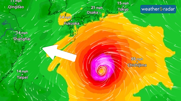
Typhoon Dolphin is heading towards the Ryukyu Islands in southern Japan. From Thursday onwards, Okinawa and the Amami Islands in particular are at risk of wind gusts exceeding 125 miles per hour, torrential rain and waves several metres high.

Further north, in the region affected by last week’s earthquake, heavy rain and storms are also expected.

Our global WindRadar shows the powerful typhoon in the Western Pacific.

In the area around Kumamoto, even small amounts of rain could trigger landslides with soil severely loosened by the earthquake.

Rapid intensification of the storm

Typhoon Dolphin has intensified from a tropical storm to a Category 5 super typhoon in the space of just two days. This rapid intensification was facilitated by very warm sea water and low wind shear.

Did you know?

Wind shear describes the change in wind speed and wind direction with altitude. If the wind direction and wind speed change significantly compared with ground level, the wind shear is high.

Although the cyclone has now weakened slightly, it remains very dangerous.

Weather & Radar editorial team
More on the topic
Hottest summer on record for Ireland. Beating 2025's record. . . Thursday, 3 September 2026
Temperature map of Ireland showing 29°C in Dublin, 26°C in Cork, 24°C in Belfast, and 23°C in Galway, with a red thermometer icon.
Thursday, 3 September 2026

Beating 2025's record

Hottest summer on record for Ireland
Cheshire Gap produces shower funnel. Local phenomenon. . . Wednesday, 9 September 2026
Weather map showing showers moving southeast from Liverpool toward Birmingham, driven by Cheshire Gap convergence across central England.
Wednesday, 9 September 2026

Local phenomenon

Cheshire Gap produces shower funnel
Severe weather in southern Europe. Thunderstorms & heavy rain. . . Wednesday, 9 September 2026
On the left, dark storm clouds over a coastline. On the right, a weather map shows thunderstorms over the western Mediterranean, with warning symbols for tornadoes, storms and hail.
Wednesday, 9 September 2026

Thunderstorms & heavy rain

Severe weather in southern Europe
All weather news
This might also interest you
A frozen start to the weekend. Icy conditions. . . Friday, 13 February 2026
UK temperature map dated 14.02 showing widespread subzero values in blue shading, with readings such as −4 in Glasgow, −3 in Dublin, and −2 in London, alongside a blue thermometer icon.
Friday, 13 February 2026

Icy conditions

A frozen start to the weekend
Seasonal warmth between spring thunder. Your weather - Your shots. . . Sunday, 19 April 2026
Split image showing coastal sunset with layered lenticular clouds over rooftops and palm trees on the left, and a green valley with river and hills under soft daylight on the right.
Sunday, 19 April 2026

Your weather - Your shots

Seasonal warmth between spring thunder
A stormy week in the skies above. Your weather - Your shots. . . Sunday, 30 August 2026
Split image showing lightning branching beneath dark storm clouds above rooftops on the left and an orange-pink sunset over a calm sea on the right.
Sunday, 30 August 2026

Your weather - Your shots

A stormy week in the skies above
All articles
Weather & Radar

Weather & Radar is also available on

Google Play StoreApp Store

Company

Contact us Privacy Policy Legal info Accessibility statement

Services

Uploader

Socials

facebooktwittertikToklinkList