Home
Weather London
WeatherRadar
RainfallRadar
TemperatureRadar
WindRadar
LightningRadar
Weather News
Editor's Pick
Discover the app
Weather widget
Contact us
Apps
Career
    Home / Editor's Pick /

    Influence of cold air - Patchwork quilt of showers over Europe

10:00
18 November 2025

Influence of cold air
Patchwork quilt of showers over Europe

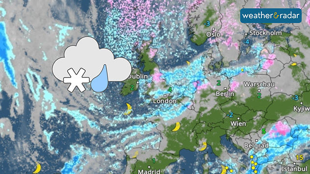
WeatherRadar: Numerous rain and snow showers are moving across northern and western Europe.

The WeatherRadar currently looks like a “patchwork quilt”, with many rain and snow showers are forming this week from the North Sea and Arctic Ocean.

Countless showers over north-western EuropeWeather radar

These are moving southwards, initially passing over the UK and Ireland before moving into France and Central Europe.

From the middle of the week, showers will also develop over the Bay of Biscay, targeting Spain and Portugal.

The cause of the countless showers is very cold air in higher layers of the atmosphere, which sweeps over warmer seawater, which is often still around 10 °C at this time of year.

The large temperature differences above and below cause particularly heavy shower activity.

Dr. Bernd Maurer
Ryan Hathaway

More on the topic

First major storm of the season. Storm Austen named. . . Tuesday, 20 October 2026
On the left, WindRadar shows a storm system over the UK with strong winds. On the right, high waves are crashing against a sea wall. A warning symbol indicates a storm.
Tuesday, 20 October 2026

Storm Austen named

First major storm of the season
Storm Boelo named. Weekend impacts. . . Thursday, 22 October 2026
Split weather maps showing Storm Boelo northwest of Scotland, winds reaching 50 mph near Glasgow and Liverpool, and spiralling Atlantic rain bands.
Thursday, 22 October 2026

Weekend impacts

Storm Boelo named
Storm Austen approaches. What to expect tonight. . . Thursday, 22 October 2026
Split image showing a wind map with 65 mph near Brest and a swirling storm south of England, beside a man wearing glasses and holding a microphone.
Thursday, 22 October 2026

What to expect tonight

Storm Austen approaches
All weather news

This might also interest you

Flooding, gales, and heavy snow. Storm Chandra. . . Tuesday, 27 January 2026
Split image showing aerial flooding in a town with muddy water covering roads on the left, and a rural road on the right blocked by heavy snowfall with vans stopped and a person walking in snow.
Tuesday, 27 January 2026

Storm Chandra

Flooding, gales, and heavy snow
Seasonal warmth between spring thunder. Your weather - Your shots. . . Sunday, 19 April 2026
Split image showing coastal sunset with layered lenticular clouds over rooftops and palm trees on the left, and a green valley with river and hills under soft daylight on the right.
Sunday, 19 April 2026

Your weather - Your shots

Seasonal warmth between spring thunder
A stormy week in the skies above. Your weather - Your shots. . . Sunday, 30 August 2026
Split image showing lightning branching beneath dark storm clouds above rooftops on the left and an orange-pink sunset over a calm sea on the right.
Sunday, 30 August 2026

Your weather - Your shots

A stormy week in the skies above
All articles
Weather & Radar

Weather & Radar is also available on

Google Play StoreApp Store

Company

Contact us Privacy Policy Legal info Accessibility statement

Services

Uploader

Socials

facebooktwittertikToklinkList