Home
Weather London
WeatherRadar
RainfallRadar
TemperatureRadar
WindRadar
LightningRadar
Weather News
Editor's Pick
Discover the app
Weather widget
Contact us
Apps
Career
    Home / Editor's Pick /

    In the coming days - Fresh low brings stronger gusting winds

10:50
25 February 2026

In the coming days
Pressure setup brings renewed gusts

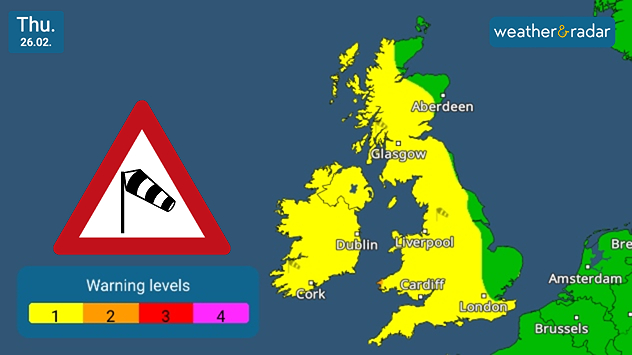
UK & Ireland warning map dated Thu 26.02 showing yellow wind warning levels across much of Britain and Ireland, with a red triangular wind warning icon and a legend indicating levels 1 to 4.
Thursday sees widespread warnings for developing winds.

Mild but gusty conditions continue into Thursday, with yet more rainfall moving in, and strengthening winds across the UK and Ireland.

Currently, low-level weather warnings cover the entirety of Ireland, and much of the UK too with only a few areas to the east of Scotland and England escaping the incoming gusts.

A low-pressure area which sits just off the coast of Iceland is responsible for the change in conditions.

The winds ease for Ireland and Scotland by Friday evening, though continue across Wales and England into the weekend.

Ryan Hathaway

More on the topic

Storm Boelo named. Weekend impacts. . . Thursday, 22 October 2026
Split weather maps showing Storm Boelo northwest of Scotland, winds reaching 50 mph near Glasgow and Liverpool, and spiralling Atlantic rain bands.
Thursday, 22 October 2026

Weekend impacts

Storm Boelo named
Calmer autumn views on a stormy week. Your weather - Your shots. . . Sunday, 25 October 2026
Split image showing swirling orange-pink sunset clouds above green countryside and golden wispy clouds over a tree-lined car park.
Sunday, 25 October 2026

Your weather - Your shots

Calmer autumn views on a stormy week
Shooting stars from the Orionids peak. Mixed visibility overnight. . . Wednesday, 21 October 2026
Split image showing a bright green meteor streaking across a starry night sky beside a UK weather map with rain over Scotland and southern England.
Wednesday, 21 October 2026

Mixed visibility overnight

Shooting stars from the Orionids peak
All weather news

This might also interest you

Flooding, gales, and heavy snow. Storm Chandra. . . Tuesday, 27 January 2026
Split image showing aerial flooding in a town with muddy water covering roads on the left, and a rural road on the right blocked by heavy snowfall with vans stopped and a person walking in snow.
Tuesday, 27 January 2026

Storm Chandra

Flooding, gales, and heavy snow
Bright and warm conditions take hold. Spring-like outlook. . . Thursday, 23 April 2026
Split UK map showing warm temperatures up to 21 degrees in orange on the left and clear sunny conditions with temperatures from 12 to 18 degrees on the right, with sun icons across the country.
Thursday, 23 April 2026

Spring-like outlook

Bright and warm conditions take hold
A frozen start to the weekend. Icy conditions. . . Friday, 13 February 2026
UK temperature map dated 14.02 showing widespread subzero values in blue shading, with readings such as −4 in Glasgow, −3 in Dublin, and −2 in London, alongside a blue thermometer icon.
Friday, 13 February 2026

Icy conditions

A frozen start to the weekend
All articles
Weather & Radar

Weather & Radar is also available on

Google Play StoreApp Store

Company

Contact us Privacy Policy Legal info Accessibility statement

Services

Uploader

Socials

facebooktwittertikToklinkList