Home
Weather London
WeatherRadar
RainfallRadar
TemperatureRadar
WindRadar
LightningRadar
Weather News
Editor's Pick
Discover the app
Weather widget
Contact us
Apps
Career
    Home / Editor's Pick /

    Icy spells in the Southern Hemisphere - Snow in the Andes

13:00
28 July 2026

Snow in the Andes
Icy spells in the Southern Hemisphere

Whilst we are in the middle of summer, it is the depths of winter in the southern hemisphere. Temperatures in South America, in the southern Andes, can drop to as low as -20°C.

At the same time, widespread falls of 50 to 80 cm of fresh snow are expected there by the weekend, with even more in some places. It will also remain bitterly cold in parts of Argentina. In Patagonia, extreme cold warnings are in place.

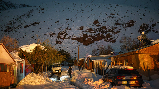
Snow-covered houses and vehicles in Alto del Carmen in northern Chile. A severe winter storm has brought heavy snowfall and hit the region hard.
A winter storm hit northern Chile as early as last week. The small community of Alto del Carmen was cut off from the outside world for a time. - © dpa

Even Australia is shivering. In the state of New South Wales, temperatures were recently recorded as low as around -9°C, and in parts of Queensland, -5°C. In many places, it was the coldest morning of this winter.

Winter is set to intensify even further in south-eastern Australia. A cold front is set to bring 10 to 20 cm of fresh snow to the ski resorts there. From Melbourne to Canberra, afternoon temperatures will only reach 9 to 12°C.

Tommy Kühnlein

More on the topic

Severe weather in the south of France. Holiday spots affected. . . Monday, 19 October 2026
A severe weather warning for heavy rain has been issued for the south of France.
Monday, 19 October 2026

Holiday spots affected

Severe weather in the south of France
Preparing for the storms. What to do now. . . Thursday, 22 October 2026
Split image showing Storm Austen winds up to 65 mph near Brest and 55 mph near Plymouth, alongside fallen tree branches on a cordoned-off park path.
Thursday, 22 October 2026

What to do now

Preparing for the storms
Overnight impacts as Austen hits. Power cuts, travel issues. . . Friday, 23 October 2026
Split image showing floodwater surging beneath a railway bridge at night and a wind map with low pressure over the English Channel and 60 mph near Brest.
Friday, 23 October 2026

Power cuts, travel issues

Overnight impacts as Austen hits
All weather news

This might also interest you

A frozen start to the weekend. Icy conditions. . . Friday, 13 February 2026
UK temperature map dated 14.02 showing widespread subzero values in blue shading, with readings such as −4 in Glasgow, −3 in Dublin, and −2 in London, alongside a blue thermometer icon.
Friday, 13 February 2026

Icy conditions

A frozen start to the weekend
Bright and warm conditions take hold. Spring-like outlook. . . Thursday, 23 April 2026
Split UK map showing warm temperatures up to 21 degrees in orange on the left and clear sunny conditions with temperatures from 12 to 18 degrees on the right, with sun icons across the country.
Thursday, 23 April 2026

Spring-like outlook

Bright and warm conditions take hold
Seasonal warmth between spring thunder. Your weather - Your shots. . . Sunday, 19 April 2026
Split image showing coastal sunset with layered lenticular clouds over rooftops and palm trees on the left, and a green valley with river and hills under soft daylight on the right.
Sunday, 19 April 2026

Your weather - Your shots

Seasonal warmth between spring thunder
All articles
Weather & Radar

Weather & Radar is also available on

Google Play StoreApp Store

Company

Contact us Privacy Policy Legal info Accessibility statement

Services

Uploader

Socials

facebooktwittertikToklinkList