Home
Weather London
WeatherRadar
RainfallRadar
TemperatureRadar
WindRadar
LightningRadar
Weather News
Editor's Pick
Discover the app
Weather widget
Contact us
Apps
Career
    Home / Editor's Pick /

    Hurricane strength winds - Peak gust of 108 mph from Floris

13:15
4 August 2025

Hurricane strength winds
Peak gust of 108 mph from Floris

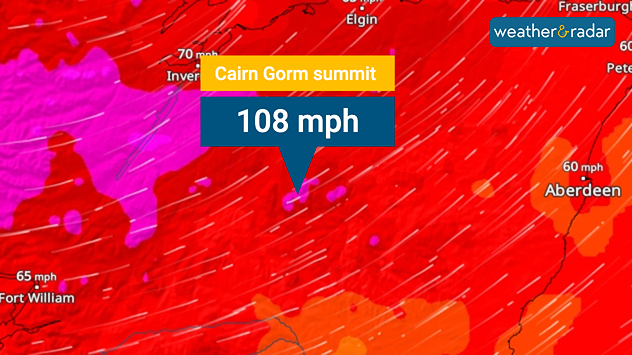
Wind map showing a gust speed of 108 miles per hour at the summit of Cairn Gorm.
Extreme wind gusts felt in the Highlands.

Storm Floris brings hurricane strength wind gusts to Scotland, with a current peak of 108 mph.

This current record, observed at the Cairn Gorm summit, is the equivalent to the winds of a Category 2 hurricane. Shortly before this, a peak of 106 mph was recorded at Aonach Mor and Cairnwell.

Hurricane?

Although a gust peaked at hurricane level, in actuality real hurricanes see sustained winds rather than just peak gusts, making them far more damaging.

The conditions have produced disruption on a bank holiday for Scotland. Edinburgh Zoo and the city's castle are closed, while falling trees have blocked train lines and some flights from Glasgow Airport were cancelled.

Privacy Policy

Elsewhere, around 10,000 properties in the north-west of Ireland experienced a power cut earlier in the day, with a separate outage in Northern Ireland.

On the roads, some bridges are closed for safety, while Police Scotland have asked drivers to avoid an area of Wester Ross where camper vans were blown over by the severe gusts.

Track Floris on the WindRadar
Ryan Hathaway
More on the topic
More rain needed to ease drought. Reservoirs still falling. . . Tuesday, 8 September 2026
Aerial view of a depleted reservoir with exposed banks and a narrow winding stream through the dry basin, surrounded by green hills and roads.
Tuesday, 8 September 2026

Reservoirs still falling

More rain needed to ease drought
Extreme weather contrasts in Europe. Heat versus constant rain. . . Thursday, 3 September 2026
On the left, the Temperature Radar shows high temperatures in Spain; on the right, the Weather Radar shows rain in Central Europe
Thursday, 3 September 2026

Heat versus constant rain

Extreme weather contrasts in Europe
Cheshire Gap produces shower funnel. Local phenomenon. . . Wednesday, 9 September 2026
Weather map showing showers moving southeast from Liverpool toward Birmingham, driven by Cheshire Gap convergence across central England.
Wednesday, 9 September 2026

Local phenomenon

Cheshire Gap produces shower funnel
All weather news
This might also interest you
Bright and warm conditions take hold. Spring-like outlook. . . Thursday, 23 April 2026
Split UK map showing warm temperatures up to 21 degrees in orange on the left and clear sunny conditions with temperatures from 12 to 18 degrees on the right, with sun icons across the country.
Thursday, 23 April 2026

Spring-like outlook

Bright and warm conditions take hold
Storm Chandra makes impact. Severe gales & heavy rain. . . Tuesday, 27 January 2026
Split image showing strong winds over the UK on a forecast map and widespread rain and snow on a weather radar map.
Tuesday, 27 January 2026

Severe gales & heavy rain

Storm Chandra makes impact
Flooding, gales, and heavy snow. Storm Chandra. . . Tuesday, 27 January 2026
Split image showing aerial flooding in a town with muddy water covering roads on the left, and a rural road on the right blocked by heavy snowfall with vans stopped and a person walking in snow.
Tuesday, 27 January 2026

Storm Chandra

Flooding, gales, and heavy snow
All articles
Weather & Radar

Weather & Radar is also available on

Google Play StoreApp Store

Company

Contact us Privacy Policy Legal info Accessibility statement

Services

Uploader

Socials

facebooktwittertikToklinkList