Home
Weather London
WeatherRadar
RainfallRadar
TemperatureRadar
WindRadar
LightningRadar
Weather News
Editor's Pick
Discover the app
Weather widget
Contact us
Apps
Career
    Home / Editor's Pick /

    Hurricane POLO remains dangerous – Numerous storms in the Pacific

09:50
24 September 2026

Many storms in the Pacific
Hurricane POLO remains dangerous

Schools and ports remain closed, and swimming is prohibited on Mexico’s beaches. Hurricane POLO has once again reached the highest category, 5. Although it is remaining offshore, heavy rain continues to pose a risk of flooding and landslides.

Follow hurricanes liveWindRadar worldwide

POLO’s development has been extraordinary: in the space of just around 40 hours, it intensified from a tropical depression to a Category 5 hurricane. Further west, Hurricane ODALYS is also making its way across the ocean, but is currently having no impact on land.

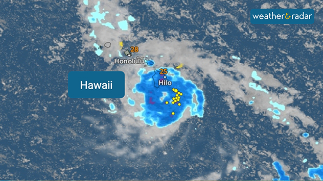
New hurricane threat for Hawaii

Hawaii is also under threat from a hurricane: another tropical storm, named NOLO, could intensify significantly by Friday and pass south of the Big Island. Heavy rain, flooding and landslides are likely to cause impacts there once again. For Hawaii, this would already be the fourth tropical storm of the season – a new record.

Niklas Weise

More on the topic

First major storm of the season. Storm Austen named. . . Tuesday, 20 October 2026
On the left, WindRadar shows a storm system over the UK with strong winds. On the right, high waves are crashing against a sea wall. A warning symbol indicates a storm.
Tuesday, 20 October 2026

Storm Austen named

First major storm of the season
Storm Boelo named. Weekend impacts. . . Thursday, 22 October 2026
Split weather maps showing Storm Boelo northwest of Scotland, winds reaching 50 mph near Glasgow and Liverpool, and spiralling Atlantic rain bands.
Thursday, 22 October 2026

Weekend impacts

Storm Boelo named
Storm Austen approaches. What to expect tonight. . . Thursday, 22 October 2026
Split image showing a wind map with 65 mph near Brest and a swirling storm south of England, beside a man wearing glasses and holding a microphone.
Thursday, 22 October 2026

What to expect tonight

Storm Austen approaches
All weather news

This might also interest you

Bright and warm conditions take hold. Spring-like outlook. . . Thursday, 23 April 2026
Split UK map showing warm temperatures up to 21 degrees in orange on the left and clear sunny conditions with temperatures from 12 to 18 degrees on the right, with sun icons across the country.
Thursday, 23 April 2026

Spring-like outlook

Bright and warm conditions take hold
New records for England and Wales. Broken again tomorrow?. . . Thursday, 25 June 2026
Temperature map of southwest Britain on 25.06 showing extreme heat across southern Wales and southwest England, with Bute Park in Cardiff highlighted at 34.2°C and Yeovilton at 36.4°C amid widespread deep red heat zones.
Thursday, 25 June 2026

Broken again tomorrow?

New records for England and Wales
Storm Chandra makes impact. Severe gales & heavy rain. . . Tuesday, 27 January 2026
Split image showing strong winds over the UK on a forecast map and widespread rain and snow on a weather radar map.
Tuesday, 27 January 2026

Severe gales & heavy rain

Storm Chandra makes impact
All articles
Weather & Radar

Weather & Radar is also available on

Google Play StoreApp Store

Company

Contact us Privacy Policy Legal info Accessibility statement

Services

Uploader

Socials

facebooktwittertikToklinkList