Home
Weather London
WeatherRadar
RainfallRadar
TemperatureRadar
WindRadar
LightningRadar
Weather News
Editor's Pick
Discover the app
Weather widget
Contact us
Apps
Career
    Home / Editor's Pick /

    Hurricane Melissa sweeps across Jamaica: disaster in the Caribbean

09:00
29 October 2025

Disaster in the Caribbean
Hurricane Melissa sweeps across Jamaica

Privacy Policy

Hurricane Melissa has caused severe damage in Jamaica. The government has declared the Caribbean island a disaster area. Tens of thousands are seeking shelter. Melissa is now moving across Cuba.

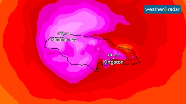
Tropical cyclone Melissa swept across Jamaica with full force, leaving severe devastation in its wake. Roofs were torn off, entire regions were flooded and over half a million households are without electricity.

WindRadar: Hurricane Melissa swept across Jamaica with wind speeds of over 185 miles per hour.

The government declared the country a disaster area. Thousands sought shelter in emergency accommodation, while rescue workers and reservists are on duty. It is still unclear how many people have lost their lives.

Only in the coming hours will it become clear how extensive the damage actually is – the consequences are only gradually coming to light.

Did you know?

Melissa is the third-strongest hurricane in the Atlantic since records began. Average wind speeds reached almost 186 miles per hour – with gusts even stronger than that.

The now Category 3 hurricane is currently moving across Cuba. More than 700,000 people have already been brought to safety there. President Díaz-Canel warned of storm surges and life-threatening flooding.

WindRadar: Track Hurricane Melissaread more
Sebastian Keßler
Ryan Hathaway
More on the topic
Rain returns to end dry spell in places. Jet stream delivery. . . Thursday, 23 July 2026
Split weather graphic showing widespread showers across the UK and Ireland on the left, and a wind forecast map on the right with a windsock icon and gusts of 25 to 35 mph, highlighting breezy conditions across the two countries.
Thursday, 23 July 2026

Jet stream delivery

Rain returns to end dry spell in places
Catastrophic forest fires in Europe. Thousands evacuated. . . Monday, 27 July 2026
A composite image showing a temperature map of south-western Europe and a drone shot of a forest fire near Cap Ferret. A warning symbol featuring a flame indicates the increased risk of forest fires.
Monday, 27 July 2026

Thousands evacuated

Catastrophic forest fires in Europe
Forest fires are getting out of control. Spain and France. . . Saturday, 25 July 2026
A split-screen image featuring a photograph and a weather map. On the left, thick, dark-grey smoke rises from several fire sites in a wooded coastal area; a calm stretch of water can be seen in the foreground. On the right, a weather map shows south-western France and northern Spain. A red arrow points from the Atlantic towards the French Atlantic coast, symbolising an onshore wind. Sunny weather is forecast for Bordeaux at around 20 degrees, and Bilbao is also expected to be sunny at around 27 degrees. A large warning sign with a flame symbol indicates an increased risk of forest fires.
Saturday, 25 July 2026

Spain and France

Forest fires are getting out of control
All weather news
This might also interest you
Storm Chandra makes impact. Severe gales & heavy rain. . . Tuesday, 27 January 2026
Split image showing strong winds over the UK on a forecast map and widespread rain and snow on a weather radar map.
Tuesday, 27 January 2026

Severe gales & heavy rain

Storm Chandra makes impact
Long-term trends need a pinch of salt. 40 °C in July?. . . Tuesday, 30 June 2026
Temperature radar of 2022 heatwave where the all-time temperature record in the UK was set. Warning symbol overlain.
Tuesday, 30 June 2026

40 °C in July?

Long-term trends need a pinch of salt
Historic Storm Éowyn arrives. On this day.... . . Saturday, 24 January 2026
Split image showing a person in a yellow jacket struggling against strong winds and heavy rain on a street at night on the left, and an Irish wind forecast map on the right with red and purple shading, gusts up to 75 mph, and a wind warning icon, divided by a curved white line.
Saturday, 24 January 2026

On this day...

Historic Storm Éowyn arrives
All articles
Weather & Radar

Weather & Radar is also available on

Google Play StoreApp Store

Company

Contact us Privacy Policy Legal info Accessibility statement

Services

Uploader

Socials

facebooktwittertikToklinkList