Home
Weather London
WeatherRadar
RainfallRadar
TemperatureRadar
WindRadar
LightningRadar
Weather News
Editor's Pick
Discover the app
Weather widget
Contact us
Apps
Career
    Home / Editor's Pick /

    Hurricane Melissa sweeps across Jamaica: disaster in the Caribbean

09:00
29 October 2025

Disaster in the Caribbean
Hurricane Melissa sweeps across Jamaica

Privacy Policy

Hurricane Melissa has caused severe damage in Jamaica. The government has declared the Caribbean island a disaster area. Tens of thousands are seeking shelter. Melissa is now moving across Cuba.

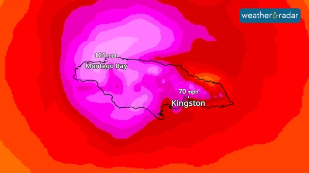
Tropical cyclone Melissa swept across Jamaica with full force, leaving severe devastation in its wake. Roofs were torn off, entire regions were flooded and over half a million households are without electricity.

WindRadar: Hurricane Melissa swept across Jamaica with wind speeds of over 185 miles per hour.

The government declared the country a disaster area. Thousands sought shelter in emergency accommodation, while rescue workers and reservists are on duty. It is still unclear how many people have lost their lives.

Only in the coming hours will it become clear how extensive the damage actually is – the consequences are only gradually coming to light.

Did you know?

Melissa is the third-strongest hurricane in the Atlantic since records began. Average wind speeds reached almost 186 miles per hour – with gusts even stronger than that.

The now Category 3 hurricane is currently moving across Cuba. More than 700,000 people have already been brought to safety there. President Díaz-Canel warned of storm surges and life-threatening flooding.

WindRadar: Track Hurricane Melissaread more
Sebastian Keßler
Ryan Hathaway
More on the topic
Low delivers days of gusty conditions. Into the weekend. . . Thursday, 17 September 2026
Wind map showing low pressure near the Faroe Islands, with winds reaching 35 mph around Aberdeen and Dublin and stronger Atlantic winds west of the UK.
Thursday, 17 September 2026

Into the weekend

Low delivers days of gusty conditions
Colourful skies and scenic clouds cover. Your weather - Your shots. . . Sunday, 20 September 2026
Split image showing a golden sunset over the sea beneath layered clouds and a pink-purple sunset reflected across calm riverside water.
Sunday, 20 September 2026

Your weather - Your shots

Colourful skies and scenic clouds cover
How El Niño impacts us worldwide. What actually is it?. . . Tuesday, 15 September 2026
teaser
Tuesday, 15 September 2026

What actually is it?

How El Niño impacts us worldwide
All weather news
This might also interest you
Seasonal warmth between spring thunder. Your weather - Your shots. . . Sunday, 19 April 2026
Split image showing coastal sunset with layered lenticular clouds over rooftops and palm trees on the left, and a green valley with river and hills under soft daylight on the right.
Sunday, 19 April 2026

Your weather - Your shots

Seasonal warmth between spring thunder
Bright and warm conditions take hold. Spring-like outlook. . . Thursday, 23 April 2026
Split UK map showing warm temperatures up to 21 degrees in orange on the left and clear sunny conditions with temperatures from 12 to 18 degrees on the right, with sun icons across the country.
Thursday, 23 April 2026

Spring-like outlook

Bright and warm conditions take hold
Super Typhoon Bavi threatens Taiwan. Up to 1,000 mm of rain. . . Wednesday, 8 July 2026
The image shows an intense tropical cyclone over the western Pacific, east of Taiwan and the Philippines. The centre of the system is depicted as a light purple and white vortex with a clearly visible eye, surrounded by a ring of red and orange areas indicating the strongest wind speeds. A white arrow marks the typhoon’s predicted track towards the north-west, in the direction of Taiwan. To the west of the storm lie the Philippines, with the cities of Manila and Cebu; to the north of these lies Taiwan, with Taipei. Further west, the Chinese coast, including Hong Kong, and parts of Vietnam can be seen. The coloured wind map shows predominantly green areas outside the storm’s core, indicating significantly weaker winds. White streamlines illustrate the typhoon’s anti-clockwise circulation in the Northern Hemisphere. The highest wind speeds are concentrated around the eye of the cyclone.
Wednesday, 8 July 2026

Up to 1,000 mm of rain

Super Typhoon Bavi threatens Taiwan
All articles
Weather & Radar

Weather & Radar is also available on

Google Play StoreApp Store

Company

Contact us Privacy Policy Legal info Accessibility statement

Services

Uploader

Socials

facebooktwittertikToklinkList