Home
Weather London
WeatherRadar
RainfallRadar
TemperatureRadar
WindRadar
LightningRadar
Weather News
Editor's Pick
Discover the app
Weather widget
Contact us
Apps
Career
    Home / Editor's Pick /

    Hurricane Melissa in the Caribbean threatens Jamaica: Extreme wind and rain

08:00
27 October 2025

Extreme wind and rain
Hurricane Melissa threatens Jamaica

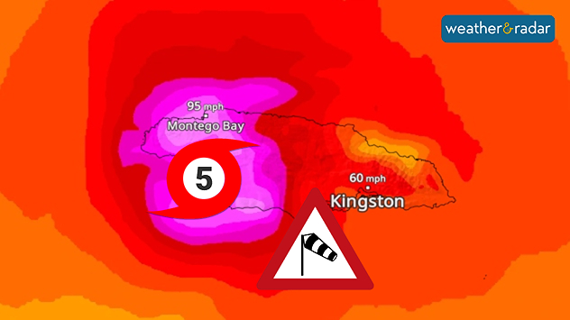
The WindRadar shows how the hurricane will cross Jamaica in the next few hours.

Hurricane Melissa over the Caribbean continues to gain strength and is expected to hit Jamaica in the next few hours as a category 5 hurricane, the highest category.

The authorities are warning of destructive and life-threatening flooding and landslides.

Did you know?

Four people have already lost their lives in Haiti and the Dominican Republic following heavy rainfall.

Melissa will hit the Caribbean island on Monday night/Tuesday morning with wind speeds of over 124 miles per hour. The west of the island will be particularly affected. As the hurricane is moving slowly, there is a risk of extreme rainfall.

Current position of the hurricaneWindRadar

The population of Jamaica has been urged to stay at home if possible. Even in the east of the island, wind speeds of around 62 miles per hour are expected. The airport in the capital Kingston has also been closed as a precautionary measure. Severe damage and storm surges are likely on the coast.

Melissa will subsequently move northwards and hit south-eastern Cuba over the course of Tuesday.

Kathrin Bogensperger
Ryan Hathaway
More on the topic
Fourth heatwave of the year. Peaking Wednesday. . . Tuesday, 28 July 2026
Temperature map of England and Wales on Wednesday 29.07 showing widespread hot conditions, with temperatures reaching 33°C near Cambridge, 32°C around London, Norwich, and Southend-on-Sea, and a large heat warning symbol highlighting elevated heat risk.
Tuesday, 28 July 2026

Peaking Wednesday

Fourth heatwave of the year
Icy spells in the Southern Hemisphere. Snow in the Andes. . . Tuesday, 28 July 2026
A composite image showing a temperature radar map of South America and a snow-covered town in Chile. The winter cold is bringing heavy snowfall to the Andes and, in some areas, snow down to lower altitudes.
Tuesday, 28 July 2026

Snow in the Andes

Icy spells in the Southern Hemisphere
Catastrophic forest fires in Europe. Thousands evacuated. . . Monday, 27 July 2026
A composite image showing a temperature map of south-western Europe and a drone shot of a forest fire near Cap Ferret. A warning symbol featuring a flame indicates the increased risk of forest fires.
Monday, 27 July 2026

Thousands evacuated

Catastrophic forest fires in Europe
All weather news
This might also interest you
Turbulent weather in the Canary Islands. Storm and rain. . . Friday, 12 December 2025
Weather graphic showing rain and wind fields over the Canary Islands and a central warning symbol.
Friday, 12 December 2025

Storm and rain

Turbulent weather in the Canary Islands
Bright and warm conditions take hold. Spring-like outlook. . . Thursday, 23 April 2026
Split UK map showing warm temperatures up to 21 degrees in orange on the left and clear sunny conditions with temperatures from 12 to 18 degrees on the right, with sun icons across the country.
Thursday, 23 April 2026

Spring-like outlook

Bright and warm conditions take hold
Flooding, gales, and heavy snow. Storm Chandra. . . Tuesday, 27 January 2026
Split image showing aerial flooding in a town with muddy water covering roads on the left, and a rural road on the right blocked by heavy snowfall with vans stopped and a person walking in snow.
Tuesday, 27 January 2026

Storm Chandra

Flooding, gales, and heavy snow
All articles
Weather & Radar

Weather & Radar is also available on

Google Play StoreApp Store

Company

Contact us Privacy Policy Legal info Accessibility statement

Services

Uploader

Socials

facebooktwittertikToklinkList