Home
Weather London
WeatherRadar
RainfallRadar
TemperatureRadar
WindRadar
LightningRadar
Weather News
Editor's Pick
Discover the app
Weather widget
Contact us
Apps
Career
    Home / Editor's Pick /

    Hurricane Ian: Dangerous threat to Florida

16:40
27 September 2022

Hurricane Ian
Dangerous threat to Florida

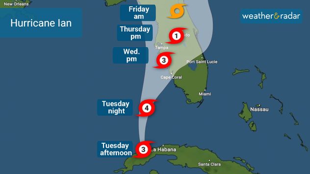
likely track of hurricane ian
Hurricane Ian's most likely track

Ian rapidly intensified into a major Category 3 hurricane prior to making landfall in Cuba, but now has its sights set on Florida.

Severe flooding from storm surges and heavy rain, accompanied by damaging winds lashed Cuba late Monday night, in what was far western Cuba's first Category 3 landfall in 14 years.

Hurricane conditions are still ongoing here, though Ian is now barrelling towards the Florida Peninsula.

Ian's outer bands of rain and gusty winds are already affecting South Florida and the Florida Keys, as below, with a tornado watch in place across southern Florida.

Thunderstorms are commonly embedded within a tropical system's outer bands, which are capable of producing tornadoes.

W​here exact landfall occurs on Wednesday night will determine which area is greatest at risk of life-threatening storm surge, with Tampa down to Fort Myers sat in a high risk zone where nearly 4m-high waves are possible.

Hurricane force winds of around 125mph are also expected along the south-west coast. Check the latest on our WindRadar.

With the system currently moving at a speed of 10mph, Ian is forecast to slow and could become stationary by meteorological definition, which is a speed of less than 5mph.

The amount of rainfall coming out of such a slow-moving or stationary system could be catastrophic, with 200-500mm of rain possible for inland areas.

Check out this Facebook Live for the latest detail on Hurricane Ian.

Weather & Radar editorial team
More on the topic
More rain needed to ease drought. Reservoirs still falling. . . Tuesday, 8 September 2026
Aerial view of a depleted reservoir with exposed banks and a narrow winding stream through the dry basin, surrounded by green hills and roads.
Tuesday, 8 September 2026

Reservoirs still falling

More rain needed to ease drought
Record ocean heat halting hurricanes. Strong El Niño influence. . . Friday, 11 September 2026
A weather map shows a calm Atlantic Ocean with no hurricanes, alongside a picture of the sea.
Friday, 11 September 2026

Strong El Niño influence

Record ocean heat halting hurricanes
A snowy winter in the Andes. Avalanches and storms. . . Tuesday, 15 September 2026
Tuesday, 15 September 2026

Avalanches and storms

A snowy winter in the Andes
All weather news
This might also interest you
Historic Storm Éowyn arrives. On this day.... . . Saturday, 24 January 2026
Split image showing a person in a yellow jacket struggling against strong winds and heavy rain on a street at night on the left, and an Irish wind forecast map on the right with red and purple shading, gusts up to 75 mph, and a wind warning icon, divided by a curved white line.
Saturday, 24 January 2026

On this day...

Historic Storm Éowyn arrives
A stormy week in the skies above. Your weather - Your shots. . . Sunday, 30 August 2026
Split image showing lightning branching beneath dark storm clouds above rooftops on the left and an orange-pink sunset over a calm sea on the right.
Sunday, 30 August 2026

Your weather - Your shots

A stormy week in the skies above
New records for England and Wales. Broken again tomorrow?. . . Thursday, 25 June 2026
Temperature map of southwest Britain on 25.06 showing extreme heat across southern Wales and southwest England, with Bute Park in Cardiff highlighted at 34.2°C and Yeovilton at 36.4°C amid widespread deep red heat zones.
Thursday, 25 June 2026

Broken again tomorrow?

New records for England and Wales
All articles
Weather & Radar

Weather & Radar is also available on

Google Play StoreApp Store

Company

Contact us Privacy Policy Legal info Accessibility statement

Services

Uploader

Socials

facebooktwittertikToklinkList