Home
Weather London
WeatherRadar
RainfallRadar
TemperatureRadar
WindRadar
LightningRadar
Weather News
Editor's Pick
Discover the app
Weather widget
Contact us
Apps
Career
    Home / Editor's Pick /

    Highest warning level: Super typhoon reaches the Philippines

12:56
22 September 2025

Highest alert level
Super typhoon reaches the Philippines

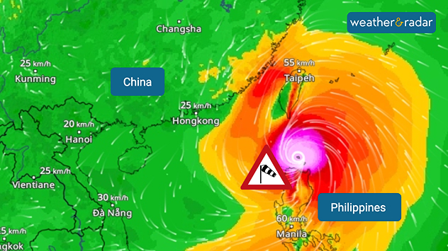
WindRadar: Typhoon RAGASA will hit the northernmost island of the Philippines on Monday.

A tropical cyclone of the strongest category has reached the Philippines. With wind speeds of up to 315 kilometres per hour, Super Typhoon RAGASA is moving westward north of the island of Luzon on Monday.

Thousands of people are already fleeing from enormous amounts of rain, metre-high storm surges and severe damage caused by hurricane-force gusts.

Did you know?

Super typhoons are among the strongest tropical cyclones. A super typhoon is equivalent to a category 5 hurricane. The Philippines is hitby an average of around 20 typhoons every year .

According to current calculations, RAGASA is continuing to move towards southern China and Hong Kong, although it is weakening. Taiwan will also be affected by heavy rain and storms.

Current situation in WindRadarFollow here
Clemens Teutsch-Zumtobel
More on the topic
Heat becoming a bigger factor in drought. New study. . . Thursday, 23 July 2026
A hand holds dry, dusty earth above a parched field. The ground is cracked and covered with plant debris – a sign of prolonged drought.
Thursday, 23 July 2026

New study

Heat becoming a bigger factor in drought
Typhoon warning for China. Up to 500 mm of rain. . . Friday, 24 July 2026
Weather map of the southern Chinese coast and Taiwan showing a powerful tropical cyclone. The eye of the storm is located near the coastal city of Shantou in the Chinese province of Guangdong. Around the centre, intense shades of red, pink and violet indicate gale-force winds, whilst a large orange wind field extends as far as the west coast of Taiwan. An overlaid windsack warning sign indicates dangerous storm winds. Cities such as Hong Kong, Guangzhou, Xiamen, Taipei and Taichung are shown, as are wind speeds and white flow lines illustrating the cyclonic air circulation.
Friday, 24 July 2026

Up to 500 mm of rain

Typhoon warning for China
Clouds return to capture the scene. Your weather - Your shots. . . Sunday, 26 July 2026
Waxing crescent Moon above vivid pink and magenta sunset clouds, with silhouetted trees along the horizon beneath a deepening blue twilight sky.
Sunday, 26 July 2026

Your weather - Your shots

Clouds return to capture the scene
All weather news
This might also interest you
Storm Chandra makes impact. Severe gales & heavy rain. . . Tuesday, 27 January 2026
Split image showing strong winds over the UK on a forecast map and widespread rain and snow on a weather radar map.
Tuesday, 27 January 2026

Severe gales & heavy rain

Storm Chandra makes impact
Historic Storm Éowyn arrives. On this day.... . . Saturday, 24 January 2026
Split image showing a person in a yellow jacket struggling against strong winds and heavy rain on a street at night on the left, and an Irish wind forecast map on the right with red and purple shading, gusts up to 75 mph, and a wind warning icon, divided by a curved white line.
Saturday, 24 January 2026

On this day...

Historic Storm Éowyn arrives
Flooding, gales, and heavy snow. Storm Chandra. . . Tuesday, 27 January 2026
Split image showing aerial flooding in a town with muddy water covering roads on the left, and a rural road on the right blocked by heavy snowfall with vans stopped and a person walking in snow.
Tuesday, 27 January 2026

Storm Chandra

Flooding, gales, and heavy snow
All articles
Weather & Radar

Weather & Radar is also available on

Google Play StoreApp Store

Company

Contact us Privacy Policy Legal info Accessibility statement

Services

Uploader

Socials

facebooktwittertikToklinkList