Home
Weather London
WeatherRadar
RainfallRadar
TemperatureRadar
WindRadar
LightningRadar
Weather News
Editor's Pick
Discover the app
Weather widget
Contact us
Apps
Career
    Home / Editor's Pick /

    Highest warning level: Super typhoon reaches the Philippines

12:56
22 September 2025

Highest alert level
Super typhoon reaches the Philippines

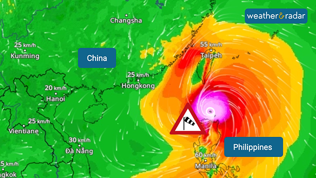
WindRadar: Typhoon RAGASA will hit the northernmost island of the Philippines on Monday.

A tropical cyclone of the strongest category has reached the Philippines. With wind speeds of up to 315 kilometres per hour, Super Typhoon RAGASA is moving westward north of the island of Luzon on Monday.

Thousands of people are already fleeing from enormous amounts of rain, metre-high storm surges and severe damage caused by hurricane-force gusts.

Did you know?

Super typhoons are among the strongest tropical cyclones. A super typhoon is equivalent to a category 5 hurricane. The Philippines is hitby an average of around 20 typhoons every year .

According to current calculations, RAGASA is continuing to move towards southern China and Hong Kong, although it is weakening. Taiwan will also be affected by heavy rain and storms.

Current situation in WindRadarFollow here
Clemens Teutsch-Zumtobel
More on the topic
Weather warning map of Wales and western Britain showing a yellow thunderstorm alert with lightning symbols, alongside a large warning triangle for lightning.
Wednesday, 27 May 2026

Wales & western England

Thunderstorm watch continues
Temperature map of southeast England showing overnight low temperatures, with Kenley highlighted at 21.3°C and surrounding areas in yellow-orange shades indicating mild nighttime conditions.
Tuesday, 26 May 2026

May heatwave

Tropical night breaks overnight record
Split image showing a bright rainbow above a residential street on the left and a dramatic ocean sunrise with glowing clouds and reflections on the sea on the right.
Sunday, 24 May 2026

Your weather - Your shots

From unsettled to warm and toasty
All weather news
This might also interest you
UK temperature map dated 14.02 showing widespread subzero values in blue shading, with readings such as −4 in Glasgow, −3 in Dublin, and −2 in London, alongside a blue thermometer icon.
Friday, 13 February 2026

Icy conditions

A frozen start to the weekend
Split UK map showing warm temperatures up to 21 degrees in orange on the left and clear sunny conditions with temperatures from 12 to 18 degrees on the right, with sun icons across the country.
Thursday, 23 April 2026

Spring-like outlook

Bright and warm conditions take hold
Split image showing coastal sunset with layered lenticular clouds over rooftops and palm trees on the left, and a green valley with river and hills under soft daylight on the right.
Sunday, 19 April 2026

Your weather - Your shots

Seasonal warmth between spring thunder
All articles
Weather & Radar

Weather & Radar is also available on

Google Play StoreApp Store

Company

Contact us Privacy Policy Legal info Accessibility statement

Services

Uploader

Socials

facebooktwittertikToklinkList