Home
Weather London
WeatherRadar
RainfallRadar
TemperatureRadar
WindRadar
LightningRadar
Weather News
Editor's Pick
Discover the app
Weather widget
Contact us
Apps
Career
    Home / Editor's Pick /

    Highest alert level - Massive typhoon in the Western Pacific

08:00
13 April 2026

Highest alert level
Massive typhoon in the Western Pacific

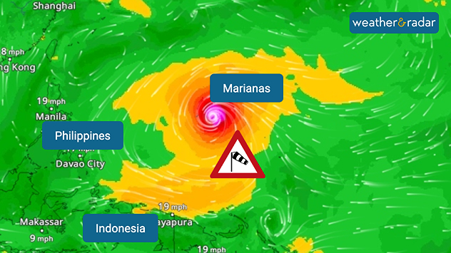
An extremely powerful typhoon has formed between Indonesia and the Philippines.

Typhoon Sinlaku is heading towards the Mariana Islands in the coming hours – with wind gusts of over 185 miles per hour, accompanied by heavy rainfall and dangerous storm surges.

WindRadar: Typhoon Sinlaku is heading towards the Mariana Islands.

The highest alert level has already been declared for the archipelago, which is part of the United States. The islands of Saipan, Tinian and Rota are particularly affected, as is Guam, the most densely populated island.

Did you know?

Super typhoons are among the strongest tropical cyclones in the world and are equivalent to a Category 5 hurricane. Guam was last hit by a severe typhoon in May 2023.

On the remote islands, flights have been cancelled and schools closed. The public are urged to avoid the coast and to leave their homes only in an emergency.

Clemens Teutsch-Zumtobel
More on the topic
Kelvin-Helmholtz wave clouds forming rolling crest shapes above modern buildings under a clear blue sky, with smooth white cloud bands resembling breaking ocean waves.
Wednesday, 6 May 2026

Waves in the sky

Kelvin-Helmholtz clouds over Swansea
The night sky glows with vivid aurora colours, showing bright green bands near the horizon blending into purple and pink streaks higher up. Dark silhouettes of trees frame the bottom of the scene.
Wednesday, 13 May 2026

To the north

Northern Lights could shine tonight
Radar image showing a thunderstorm cell over northern Italy, near Brescia and Bergamo. Next to it, several large white hailstones in a hand.
Tuesday, 12 May 2026

Severe storms in Italy

Damage caused by large hailstones
All weather news
This might also interest you
Split image showing a person in a yellow jacket struggling against strong winds and heavy rain on a street at night on the left, and an Irish wind forecast map on the right with red and purple shading, gusts up to 75 mph, and a wind warning icon, divided by a curved white line.
Saturday, 24 January 2026

On this day...

Historic Storm Éowyn arrives
Outline of Santa Claus with a yellow and white hat, "Ho-Ho-Ho" next to the outline above a Christmas tree.
Thursday, 25 December 2025

Merry Christmas!

Wishes from Weather & Radar
UK temperature map dated 14.02 showing widespread subzero values in blue shading, with readings such as −4 in Glasgow, −3 in Dublin, and −2 in London, alongside a blue thermometer icon.
Friday, 13 February 2026

Icy conditions

A frozen start to the weekend
All articles
Weather & Radar

Weather & Radar is also available on

Google Play StoreApp Store

Company

Contact us Privacy Policy Legal info Accessibility statement

Services

Uploader

Socials

facebooktwittertikToklinkList