Home
Weather London
WeatherRadar
RainfallRadar
TemperatureRadar
WindRadar
LightningRadar
Weather News
Editor's Pick
Discover the app
Weather widget
Contact us
Apps
Career
    Home /

    High pressure in control - Chilly winds but a settled outlook

16:54
2 November 2026

High pressure in control
Chilly winds but a settled outlook

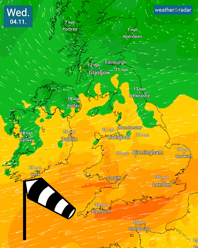
Northeasterly winds add a chill to the air for many this week.

After a stormy few weeks, it's a much more settled outlook with blocking high pressure keeping conditions mostly dry yet cloudy.

From Tuesday, the aforementioned high pressure near Scotland helps to maintain dry and settled weather. One area of note is instability in the North Sea generating potentially heavy showers for south-east England.

Almost a record-breaker

The high pressure system currently over the UK was recorded with a pressure of 1043.9 hectopascals on Monday, the November record from 1999 is 1046.7 hectopascals.

Otherwise, it's dry but with some brisk northeasterly winds adding an extra chil to the air though temperatures are around average for the time of year.

Eyes will be focused on the forecast for Thursday, any bonfire or firework plans for Guy Fawkes Night look to be safe with a generally overcast evening and just light showers to the south-west and north-east of England.

The area of high pressure steadily drifts east over the week, reaching north-western Europe by the weekend keeping the dry conditions with bright or sunny spells continuing.

Temperatures by the weekend may dip below average at first, but are likely to rise again into the new week.

London

Mo
9
12
Tu
9
12
We
8
11
Th
9
10
Fr
8
10
Sa
8
10
Su
8
11
Mo
7
11
Tu
9
12
We
10
12
Th
9
12
Fr
8
12
Sa
9
13
Su
11
15
Max (°C)
Min (°C)
moreless

Manchester

Mo
2
11
Tu
9
11
We
8
11
Th
8
11
Fr
8
10
Sa
8
10
Su
7
9
Mo
4
9
Tu
7
11
We
8
11
Th
6
10
Fr
5
11
Sa
7
11
Su
9
13
Max (°C)
Min (°C)
moreless

Dublin

Mo
5
13
Tu
5
11
We
9
12
Th
10
11
Fr
8
10
Sa
6
10
Su
5
10
Mo
5
10
Tu
9
11
We
5
9
Th
5
10
Fr
8
12
Sa
9
12
Su
10
13
Max (°C)
Min (°C)
moreless

Edinburgh

Mo
1
12
Tu
6
11
We
5
10
Th
5
10
Fr
8
10
Sa
8
9
Su
7
10
Mo
4
8
Tu
6
11
We
5
10
Th
6
12
Fr
6
11
Sa
8
12
Su
8
13
Max (°C)
Min (°C)
moreless

Cardiff

Mo
7
12
Tu
7
12
We
8
10
Th
8
9
Fr
7
9
Sa
7
11
Su
7
11
Mo
7
10
Tu
8
11
We
9
12
Th
7
11
Fr
8
12
Sa
9
13
Su
11
13
Max (°C)
Min (°C)
moreless
Ryan Hathaway

More on the topic

From late summer to storm warnings. Contrasts in Europe. . . Thursday, 29 October 2026
Split image: On the left, the temperature radar for Spain and Portugal shows readings of up to 28 degrees. On the right, waves crash onto a flooded beach dotted with parasols and sun loungers amid stormy weather.
Thursday, 29 October 2026

Contrasts in Europe

From late summer to storm warnings
Severe weather risk in the Mediterranean. Turkey and Greece. . . Tuesday, 27 October 2026
Weather map showing low pressure over the Aegean Sea, blue rain bands across Greece and Turkey, and heavy rain and thunderstorm warning symbols.
Tuesday, 27 October 2026

Turkey and Greece

Severe weather risk in the Mediterranean
Stormy winds finally easing. By the end of the week. . . Tuesday, 27 October 2026
Split wind maps showing winds of 25–40 mph across the UK and Ireland easing to 7–15 mph, with a white arrow indicating the change.
Tuesday, 27 October 2026

By the end of the week

Stormy winds finally easing
All weather news

This might also interest you

Storm Boelo named. Weekend impacts. . . Thursday, 22 October 2026
Split weather maps showing Storm Boelo northwest of Scotland, winds reaching 50 mph near Glasgow and Liverpool, and spiralling Atlantic rain bands.
Thursday, 22 October 2026

Weekend impacts

Storm Boelo named
Calmer autumn views on a stormy week. Your weather - Your shots. . . Sunday, 25 October 2026
Split image showing swirling orange-pink sunset clouds above green countryside and golden wispy clouds over a tree-lined car park.
Sunday, 25 October 2026

Your weather - Your shots

Calmer autumn views on a stormy week
Severe flooding in the south of France. Roads become rivers. . . Wednesday, 21 October 2026
Weather radar shows heavy rainfall over southern France, northern Italy, Corsica and Sardinia. A warning symbol indicates a risk of flooding.
Wednesday, 21 October 2026

Roads become rivers

Severe flooding in the south of France
All articles
Weather & Radar

Weather & Radar is also available on

Google Play StoreApp Store

Company

Contact us Privacy Policy Legal info Accessibility statement

Services

Uploader

Socials

facebooktwittertikToklinkList