Home
Weather London
WeatherRadar
RainfallRadar
TemperatureRadar
WindRadar
LightningRadar
Weather News
Editor's Pick
Discover the app
Weather widget
Contact us
Apps
Career
    Home / Editor's Pick /

    High-over-low: Blocking weather pattern at Christmas with two distinct weather systems in Europe

10:00
22 December 2025

"High over low"
Blocking weather conditions at Christmas

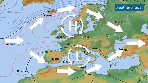
Stable "high-over-low" weather pattern with large-scale flow circulating around the high and low pressure systems.

The weather will be very stable over Christmas: an extensive and strong high-pressure area has formed over northern and Central Europe. This is contrasted by low air pressure over the Mediterranean.

The general weather situation with a high in the north and a low in the south is called "high-over-low" and is one of the so-called blocking weather situations. In this case, the weather stalls for a while because the large-scale flow is directed around the two pressure systems.

This means that the weather in Europe is divided into two parts: in the high-pressure area, it is mostly calm with sunshine, but in some areas there is also fog or clouds. In addition, it is wintry cold. An icy east wind makes it even more unpleasant in some places.

The weather at a glanceWeatherRadar for Europe

In contrast, the low pressure system is causing very changeable weather in Southern Europe with lots of precipitation, some of which is falling as rain, but often as snow, especially at higher altitudes.

Dr. Bernd Maurer
More on the topic
Parts of England inching towards drought. Low rivers & reservoirs. . . Wednesday, 22 July 2026
People relaxing in a park during hot weather ,with one person sunbathing on dry yellow grass beneath large leafy trees under a blue sky with scattered fair-weather clouds.
Wednesday, 22 July 2026

Low rivers & reservoirs

Parts of England inching towards drought
Drought for North Wales and Upper Severn. 2% of average rainfall. . . Thursday, 23 July 2026
Split image showing a July rainfall anomaly map of Europe on the left with below-average rainfall across the UK, Ireland, and much of western and central Europe, and an active moorland wildfire on the right producing flames and thick smoke near homes.
Thursday, 23 July 2026

2% of average rainfall

Drought for North Wales and Upper Severn
Heatwave breaks after remarkable run. Two weeks of heat. . . Monday, 20 July 2026
Split image showing the London skyline in hazy golden sunshine on the left and a July temperature anomaly map of Europe on the right, with above-average temperatures across the UK, Ireland, and much of western Europe highlighted in red alongside a thermometer icon.
Monday, 20 July 2026

Two weeks of heat

Heatwave breaks after remarkable run
All weather news
This might also interest you
Turbulent weather in the Canary Islands. Storm and rain. . . Friday, 12 December 2025
Weather graphic showing rain and wind fields over the Canary Islands and a central warning symbol.
Friday, 12 December 2025

Storm and rain

Turbulent weather in the Canary Islands
New records for England and Wales. Broken again tomorrow?. . . Thursday, 25 June 2026
Temperature map of southwest Britain on 25.06 showing extreme heat across southern Wales and southwest England, with Bute Park in Cardiff highlighted at 34.2°C and Yeovilton at 36.4°C amid widespread deep red heat zones.
Thursday, 25 June 2026

Broken again tomorrow?

New records for England and Wales
Seasonal warmth between spring thunder. Your weather - Your shots. . . Sunday, 19 April 2026
Split image showing coastal sunset with layered lenticular clouds over rooftops and palm trees on the left, and a green valley with river and hills under soft daylight on the right.
Sunday, 19 April 2026

Your weather - Your shots

Seasonal warmth between spring thunder
All articles
Weather & Radar

Weather & Radar is also available on

Google Play StoreApp Store

Company

Contact us Privacy Policy Legal info Accessibility statement

Services

Uploader

Socials

facebooktwittertikToklinkList