Home
Weather London
WeatherRadar
RainfallRadar
TemperatureRadar
WindRadar
LightningRadar
Weather News
Editor's Pick
Discover the app
Weather widget
Contact us
Apps
Career
    Home / Editor's Pick /

    Heavy showers prompt flash flood risk

08:51
26 August 2026

Thunder and hail
Heavy showers prompt flash flood risk

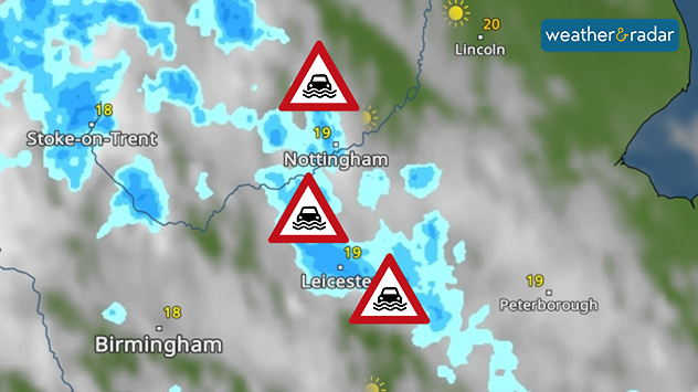
Weather radar map showing heavy shower around Nottingham and Leicester, with flood warning symbols highlightning areas at risk across the East Midlands.
Flood alerts are active across parts of the Midlands.

A number of flood alerts are already live Wednesday morning as heavy showers bring a renewed risk of flash flooding in parts of England and Wales.

Up to 50 mm of rain could fall through day, with heavy showers moving northwards in the morning. More widely accumulations of 20-30 mm are expected. Where the heaviest rain falls, surface flooding may arise.

Currently, five flood alerts cover parts of the Midlands from northern Nottinghamshire's River Maun down to tributaries in Leicester.

Further alerts are expected on Thursday, with another day of heavy rain and potential thunderstorms.

Staying on top of the flood risk

Flood alerts, warnings, and severe warnings are a live service and prone to change during the day. Keep an eye on official sources for the latest in your area.

Again, accumulations of 20 to 30 mm in a few hours are expected across the English Midlands into Wales, but with potentially higher total amounts of up to 75 mm for a few east facing areas at higher altitude.

Alongside the rainfall, the current set-up is also ripe for the outbreak of thunderstorms on both days and large hailstones are possible on Thursday too.

Ryan Hathaway
More on the topic
Equinox marks the start of autumn. Days start to get shorter. . . Wednesday, 23 September 2026
Split image showing Stonehenge in warm sunlight beside a tree-lined park glowing with vivid orange, red, and golden autumn leaves.
Wednesday, 23 September 2026

Days start to get shorter

Equinox marks the start of autumn
Warm weather despite the start of autumn. Temperatures worldwide. . . Wednesday, 23 September 2026
Temperature Radar for the Northern Hemisphere
Wednesday, 23 September 2026

Temperatures worldwide

Warm weather despite the start of autumn
Hurricane POLO remains dangerous. Many storms in the Pacific. . . Thursday, 24 September 2026
Thursday, 24 September 2026

Many storms in the Pacific

Hurricane POLO remains dangerous
All weather news
This might also interest you
A stormy week in the skies above. Your weather - Your shots. . . Sunday, 30 August 2026
Split image showing lightning branching beneath dark storm clouds above rooftops on the left and an orange-pink sunset over a calm sea on the right.
Sunday, 30 August 2026

Your weather - Your shots

A stormy week in the skies above
Seasonal warmth between spring thunder. Your weather - Your shots. . . Sunday, 19 April 2026
Split image showing coastal sunset with layered lenticular clouds over rooftops and palm trees on the left, and a green valley with river and hills under soft daylight on the right.
Sunday, 19 April 2026

Your weather - Your shots

Seasonal warmth between spring thunder
A frozen start to the weekend. Icy conditions. . . Friday, 13 February 2026
UK temperature map dated 14.02 showing widespread subzero values in blue shading, with readings such as −4 in Glasgow, −3 in Dublin, and −2 in London, alongside a blue thermometer icon.
Friday, 13 February 2026

Icy conditions

A frozen start to the weekend
All articles
Weather & Radar

Weather & Radar is also available on

Google Play StoreApp Store

Company

Contact us Privacy Policy Legal info Accessibility statement

Services

Uploader

Socials

facebooktwittertikToklinkList