Home
Weather London
WeatherRadar
RainfallRadar
TemperatureRadar
WindRadar
LightningRadar
Weather News
Editor's Pick
Discover the app
Weather widget
Contact us
Apps
Career
    Home / Editor's Pick /

    Heavy rain and storms - Severe weather on the Canary Islands

11:05
18 March 2026

Heavy rain and storms
Severe weather on the Canary Islands

It’s not something you see every day: a powerful Atlantic low-pressure system is bringing unusually wet and stormy weather to the Canary Islands.

There is a risk of torrential rain, gale-force winds and dangerous sea conditions.

Did you know?

The Canary Islands are renowned for their mild, stable trade wind climate all year round, with plenty of sunshine and only rare extreme weather events.

Over the next few days, heavy showers and thunderstorms will continue to sweep across the archipelago. By the weekend, some areas will have received over 100 mm of rain per square metre, with significantly higher amounts in places.

The western coasts of La Palma and Tenerife are particularly affected, with rainfall of up to 200 mm possible there.

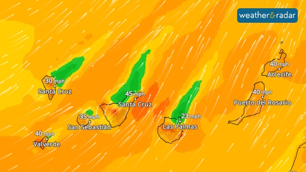
WindRadar: On Thursday, there will be a strong to gale-force south-westerly wind.

There will also be strong winds, with gusts expected particularly on Thursday and Friday. Consequently, dangerous, high waves are set to hit the coasts. The weather will remain unpleasant on the islands over the weekend.

The weekend remains turbulentCanary Islands WeatherRadar
Tommy Kühnlein

More on the topic

Calmer autumn views on a stormy week. Your weather - Your shots. . . Sunday, 25 October 2026
Split image showing swirling orange-pink sunset clouds above green countryside and golden wispy clouds over a tree-lined car park.
Sunday, 25 October 2026

Your weather - Your shots

Calmer autumn views on a stormy week
Storm Austen approaches. What to expect tonight. . . Thursday, 22 October 2026
Split image showing a wind map with 65 mph near Brest and a swirling storm south of England, beside a man wearing glasses and holding a microphone.
Thursday, 22 October 2026

What to expect tonight

Storm Austen approaches
Warnings live across the UK and Ireland. How do they work?. . . Tuesday, 20 October 2026
Weather warning map showing yellow and orange wind alerts across Ireland and England, with red level 3 areas in southwest England and a windsock symbol.
Tuesday, 20 October 2026

How do they work?

Warnings live across the UK and Ireland
All weather news

This might also interest you

A frozen start to the weekend. Icy conditions. . . Friday, 13 February 2026
UK temperature map dated 14.02 showing widespread subzero values in blue shading, with readings such as −4 in Glasgow, −3 in Dublin, and −2 in London, alongside a blue thermometer icon.
Friday, 13 February 2026

Icy conditions

A frozen start to the weekend
A stormy week in the skies above. Your weather - Your shots. . . Sunday, 30 August 2026
Split image showing lightning branching beneath dark storm clouds above rooftops on the left and an orange-pink sunset over a calm sea on the right.
Sunday, 30 August 2026

Your weather - Your shots

A stormy week in the skies above
Long-term trends need a pinch of salt. 40 °C in July?. . . Tuesday, 30 June 2026
Temperature radar of 2022 heatwave where the all-time temperature record in the UK was set. Warning symbol overlain.
Tuesday, 30 June 2026

40 °C in July?

Long-term trends need a pinch of salt
All articles
Weather & Radar

Weather & Radar is also available on

Google Play StoreApp Store

Company

Contact us Privacy Policy Legal info Accessibility statement

Services

Uploader

Socials

facebooktwittertikToklinkList