Home
Weather London
WeatherRadar
RainfallRadar
TemperatureRadar
WindRadar
LightningRadar
Weather News
Editor's Pick
Discover the app
Weather widget
Contact us
Apps
Career
    Home / Editor's Pick /

    Heavy monsoon rain - Flood disaster on Sumatra

11:00
3 December 2025

Heavy monsoon rain
Flood disaster on Sumatra

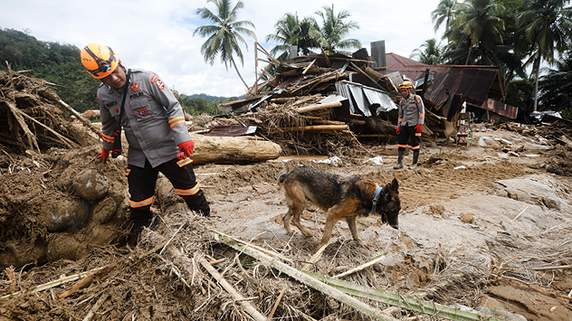
The picture shows a destroyed house with rubble and debris. Two people and a dog are searching for victims.
Rescue workers with sniffer dogs search the devastated areas for possible victims. - © dpa

The Indonesian island of Sumatra is battling one of the worst floods in recent years. More than 750 people have died in the floods and landslides.

The number of missing persons now stands at around 650, and approximately 2,600 residents have been injured.

More rain is on the way

This was preceded by days of heavy monsoon rains. Thousands of houses have been destroyed, and many roads are still blocked by debris, mud, and rubble.

The military and rescue teams are working tirelessly to search for missing persons, clear roads and distribute food, water, and medicine.

Other provinces could soon face extreme weather conditions too: in Indonesia, the peak of the rainy season is just beginning.

Weather & Radar editorial team
with material from dpa
More on the topic
Low delivers days of gusty conditions. Into the weekend. . . Thursday, 17 September 2026
Wind map showing low pressure near the Faroe Islands, with winds reaching 35 mph around Aberdeen and Dublin and stronger Atlantic winds west of the UK.
Thursday, 17 September 2026

Into the weekend

Low delivers days of gusty conditions
Europe split in two distinct patterns. Autumn meets summer. . . Tuesday, 22 September 2026
Weather maps show a storm over the North Atlantic and temperatures of up to 37 degrees in Spain and Portugal.
Tuesday, 22 September 2026

Autumn meets summer

Europe split in two distinct patterns
Hurricane POLO remains dangerous. Many storms in the Pacific. . . Thursday, 24 September 2026
Thursday, 24 September 2026

Many storms in the Pacific

Hurricane POLO remains dangerous
All weather news
This might also interest you
Super Typhoon Bavi threatens Taiwan. Up to 1,000 mm of rain. . . Wednesday, 8 July 2026
The image shows an intense tropical cyclone over the western Pacific, east of Taiwan and the Philippines. The centre of the system is depicted as a light purple and white vortex with a clearly visible eye, surrounded by a ring of red and orange areas indicating the strongest wind speeds. A white arrow marks the typhoon’s predicted track towards the north-west, in the direction of Taiwan. To the west of the storm lie the Philippines, with the cities of Manila and Cebu; to the north of these lies Taiwan, with Taipei. Further west, the Chinese coast, including Hong Kong, and parts of Vietnam can be seen. The coloured wind map shows predominantly green areas outside the storm’s core, indicating significantly weaker winds. White streamlines illustrate the typhoon’s anti-clockwise circulation in the Northern Hemisphere. The highest wind speeds are concentrated around the eye of the cyclone.
Wednesday, 8 July 2026

Up to 1,000 mm of rain

Super Typhoon Bavi threatens Taiwan
Long-term trends need a pinch of salt. 40 °C in July?. . . Tuesday, 30 June 2026
Temperature radar of 2022 heatwave where the all-time temperature record in the UK was set. Warning symbol overlain.
Tuesday, 30 June 2026

40 °C in July?

Long-term trends need a pinch of salt
Bright and warm conditions take hold. Spring-like outlook. . . Thursday, 23 April 2026
Split UK map showing warm temperatures up to 21 degrees in orange on the left and clear sunny conditions with temperatures from 12 to 18 degrees on the right, with sun icons across the country.
Thursday, 23 April 2026

Spring-like outlook

Bright and warm conditions take hold
All articles
Weather & Radar

Weather & Radar is also available on

Google Play StoreApp Store

Company

Contact us Privacy Policy Legal info Accessibility statement

Services

Uploader

Socials

facebooktwittertikToklinkList