Home
Weather London
WeatherRadar
RainfallRadar
TemperatureRadar
WindRadar
LightningRadar
Weather News
Editor's Pick
Discover the app
Weather widget
Contact us
Apps
Career
    Home / Editor's Pick /

    Heading over 40°C? Long-term trends need a pinch of salt

13:09
21 July 2026

Heading over 40°C?
Long-term trends need a pinch of salt

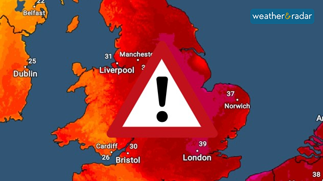
Temperature map of England showing widespread extreme heat, with temperatures reaching 39°C near London, 37°C near Norwich, and over 30°C across much of the country, alongside a large warning symbol indicating dangerous conditions.
Another heatwave is likely, but hitting 40°C is less so.

Once again, weather models are being posted online showing widespread regions of the UK passing 40°C at the start of August, and once again these need some extra context.

While some reports are writing of the next severe heatwave, it is unlikely to be exactly what is currently stated. Beyond three to five days it gets incredibly difficult to pinpoint specific weather conditions. So, posts suggesting highs of 40 or 41 °C around August 1st should be approached with caution.

What is actually happening? These posts are using one extreme output of one weather model. Beyond the five day mark a forecast is no longer possible, only a trend of where conditions are roughly expected to reach.

London

Tu
19
26
We
17
24
Th
15
22
Fr
14
20
Sa
13
21
Su
13
21
Mo
14
22
Tu
15
23
We
17
25
Th
16
25
Fr
16
24
Sa
17
25
Su
16
24
Mo
16
24
Max (°C)
Min (°C)
moreless

Manchester

Tu
16
18
We
14
19
Th
13
16
Fr
10
18
Sa
9
18
Su
7
19
Mo
11
21
Tu
12
21
We
14
21
Th
13
21
Fr
13
21
Sa
13
22
Su
11
19
Mo
12
20
Max (°C)
Min (°C)
moreless

Dublin

Tu
16
19
We
13
19
Th
13
17
Fr
10
16
Sa
7
17
Su
7
18
Mo
10
19
Tu
12
21
We
12
19
Th
11
20
Fr
13
21
Sa
11
20
Su
10
19
Mo
11
19
Max (°C)
Min (°C)
moreless

Edinburgh

Tu
15
18
We
12
17
Th
11
15
Fr
8
15
Sa
8
17
Su
10
18
Mo
10
19
Tu
10
19
We
12
19
Th
11
19
Fr
12
20
Sa
12
20
Su
11
19
Mo
12
19
Max (°C)
Min (°C)
moreless

Cardiff

Tu
17
23
We
15
21
Th
14
20
Fr
12
19
Sa
12
20
Su
10
21
Mo
12
21
Tu
14
22
We
15
21
Th
14
23
Fr
15
23
Sa
15
23
Su
14
21
Mo
14
22
Max (°C)
Min (°C)
moreless

The particular 40°C+ claim on August 1st is an extreme scenario which is unlikely. If several model runs point in this direction, it becomes more reliable. This is not the case currently.

At this point we know that we are likely to see another hot spell, very likely becoming the fourth heatwave of the season, but we do not yet know how hot it will be.

Forecast vs trend

Forecasts focus on specific conditions in the short-term, usually accurate up to five days. Trends use data and probabilities to determine a more general outlook for a longer timeframe without details.

Trends are updated regularly with new data, and can change many times before we get to the dates mentioned.

It is best to remember that the details will only become clear as we get closer to the date. Keep an eye on the 14 day weather card and the TemperatureRadar in the meantime.

Ryan Hathaway
More on the topic
Hottest day of the year so far. Close to August record. . . Thursday, 13 August 2026
Temperature map of London showing 38.1°C at Kew Gardens, with surrounding readings of 35–36°C and deep red shading indicating extreme heat.
Thursday, 13 August 2026

Close to August record

Hottest day of the year so far
An eventful week on camera. Your weather - Your shots. . . Sunday, 16 August 2026
Split image showing a golden sunset reflecting across calm sea on the left and a rugged mountain rising above green vegetation and water beneath broken clouds on the right.
Sunday, 16 August 2026

Your weather - Your shots

An eventful week on camera
Solar eclipse on Wednesday. Save the date. . . Monday, 10 August 2026
People are watching a solar eclipse. The sun is already partially obscured. Next to it is the weather radar forecast for Wednesday, showing an almost cloudless sky.
Monday, 10 August 2026

Save the date

Solar eclipse on Wednesday
All weather news
This might also interest you
Historic Storm Éowyn arrives. On this day.... . . Saturday, 24 January 2026
Split image showing a person in a yellow jacket struggling against strong winds and heavy rain on a street at night on the left, and an Irish wind forecast map on the right with red and purple shading, gusts up to 75 mph, and a wind warning icon, divided by a curved white line.
Saturday, 24 January 2026

On this day...

Historic Storm Éowyn arrives
Bright and warm conditions take hold. Spring-like outlook. . . Thursday, 23 April 2026
Split UK map showing warm temperatures up to 21 degrees in orange on the left and clear sunny conditions with temperatures from 12 to 18 degrees on the right, with sun icons across the country.
Thursday, 23 April 2026

Spring-like outlook

Bright and warm conditions take hold
A frozen start to the weekend. Icy conditions. . . Friday, 13 February 2026
UK temperature map dated 14.02 showing widespread subzero values in blue shading, with readings such as −4 in Glasgow, −3 in Dublin, and −2 in London, alongside a blue thermometer icon.
Friday, 13 February 2026

Icy conditions

A frozen start to the weekend
All articles
Weather & Radar

Weather & Radar is also available on

Google Play StoreApp Store

Company

Contact us Privacy Policy Legal info Accessibility statement

Services

Uploader

Socials

facebooktwittertikToklinkList