Home
Weather London
WeatherRadar
RainfallRadar
TemperatureRadar
WindRadar
LightningRadar
Weather News
Editor's Pick
Discover the app
Weather widget
Contact us
Apps
Career
    Home / Editor's Pick /

    Have you ever wondered? When do storms get names?

11:00
20 August 2023

Have you ever wondered?
When do storms get names?

wind sock

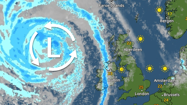
Storm Betty marked just the second named storm of the 2022-23 season. Do you know when storms get names?

Names are chosen each year by members of the public. In the UK and Ireland, we share our names with the Netherlands.

Storms are named when they could cause ‘medium’ or ‘high’ impacts in one of the three partner countries.

It is said that the naming practice helps provide consistent and authoritative messaging in times of severe weather.

Storms first started receiving names in the UK and Ireland in 2015, and in November that year, Storm Abigail became the first ever named storm.

Other groups of countries in Europe also name storms, and it is agreed practice that when any national weather service names a system, all other countries keep the same name.

Ex-hurricanes which cross the Atlantic Ocean also retain the name they were given by the US National Hurricane Centre in Miami – as happened with Ophelia in October 2017.

There are some rules when it comes to names. The letters Q, U, X, Y, and Z are not used. Party due to a lack of variety in names and also to maintain convention with the US hurricane warning system.

The 2022-23 storm season began last September, but it took until August for Storm Antoni to begin the list, right as the season is set to come to an end just weeks before the 2023-24 season kicks off.

Ryan Hathaway
More on the topic
Cheshire Gap produces shower funnel. Local phenomenon. . . Wednesday, 9 September 2026
Weather map showing showers moving southeast from Liverpool toward Birmingham, driven by Cheshire Gap convergence across central England.
Wednesday, 9 September 2026

Local phenomenon

Cheshire Gap produces shower funnel
Severe weather in southern Europe. Thunderstorms & heavy rain. . . Wednesday, 9 September 2026
On the left, dark storm clouds over a coastline. On the right, a weather map shows thunderstorms over the western Mediterranean, with warning symbols for tornadoes, storms and hail.
Wednesday, 9 September 2026

Thunderstorms & heavy rain

Severe weather in southern Europe
Autumn arrives with vivid colour. Your weather - Your shots. . . Sunday, 6 September 2026
Split image showing peach-lit textured clouds above silhouetted trees and golden cumulus clouds reflected in a calm canal lined with boats.
Sunday, 6 September 2026

Your weather - Your shots

Autumn arrives with vivid colour
All weather news
This might also interest you
Seasonal warmth between spring thunder. Your weather - Your shots. . . Sunday, 19 April 2026
Split image showing coastal sunset with layered lenticular clouds over rooftops and palm trees on the left, and a green valley with river and hills under soft daylight on the right.
Sunday, 19 April 2026

Your weather - Your shots

Seasonal warmth between spring thunder
Long-term trends need a pinch of salt. 40 °C in July?. . . Tuesday, 30 June 2026
Temperature radar of 2022 heatwave where the all-time temperature record in the UK was set. Warning symbol overlain.
Tuesday, 30 June 2026

40 °C in July?

Long-term trends need a pinch of salt
Super Typhoon Bavi threatens Taiwan. Up to 1,000 mm of rain. . . Wednesday, 8 July 2026
The image shows an intense tropical cyclone over the western Pacific, east of Taiwan and the Philippines. The centre of the system is depicted as a light purple and white vortex with a clearly visible eye, surrounded by a ring of red and orange areas indicating the strongest wind speeds. A white arrow marks the typhoon’s predicted track towards the north-west, in the direction of Taiwan. To the west of the storm lie the Philippines, with the cities of Manila and Cebu; to the north of these lies Taiwan, with Taipei. Further west, the Chinese coast, including Hong Kong, and parts of Vietnam can be seen. The coloured wind map shows predominantly green areas outside the storm’s core, indicating significantly weaker winds. White streamlines illustrate the typhoon’s anti-clockwise circulation in the Northern Hemisphere. The highest wind speeds are concentrated around the eye of the cyclone.
Wednesday, 8 July 2026

Up to 1,000 mm of rain

Super Typhoon Bavi threatens Taiwan
All articles
Weather & Radar

Weather & Radar is also available on

Google Play StoreApp Store

Company

Contact us Privacy Policy Legal info Accessibility statement

Services

Uploader

Socials

facebooktwittertikToklinkList