Home
Weather London
WeatherRadar
RainfallRadar
TemperatureRadar
WindRadar
LightningRadar
Weather News
Editor's Pick
Discover the app
Weather widget
Contact us
Apps
Career
    Home / Editor's Pick /

    Hail possible too - Continued thunderstorm risk

08:00
19 May 2026

Hail possible too
Continued thunderstorm risk

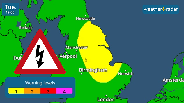
Warnings are live, but thundery showers could also form away from this area in the UK and Ireland.

As we head into the long weekend, Tuesday remains unsettled with a chance of yet more thunderstorms in the UK and Ireland.

While the most prominant risk rests from the north-east of England down to the Midlands, where warnings are live, conditions are ripe for isolated thunderstorms in Northern Ireland and the north of Ireland too.

Chances rise in the afternoon, as temperatures reach their daily highs, though rain passes through all day in a mix of showers and longer rainfall.

Aside from the thunder and lightning, some showers also turn heavier with a risk of hail returning in eastern England.

Despite the unpleasant conditions, temperatures are starting to rise with highs around 18 °C the peak around London, slightly cooler around 14-16 °C in southern Scotland and across Ireland.

Be sure to keep an eye on the day's showers via the WeatherRadar, and by the afternoon the LightningRadar captures all strikes as they happen.

Ryan Hathaway

More on the topic

Severe flooding in the south of France. Roads become rivers. . . Wednesday, 21 October 2026
Weather radar shows heavy rainfall over southern France, northern Italy, Corsica and Sardinia. A warning symbol indicates a risk of flooding.
Wednesday, 21 October 2026

Roads become rivers

Severe flooding in the south of France
Storm Boelo named. Weekend impacts. . . Thursday, 22 October 2026
Split weather maps showing Storm Boelo northwest of Scotland, winds reaching 50 mph near Glasgow and Liverpool, and spiralling Atlantic rain bands.
Thursday, 22 October 2026

Weekend impacts

Storm Boelo named
First major storm of the season. Storm Austen named. . . Tuesday, 20 October 2026
On the left, WindRadar shows a storm system over the UK with strong winds. On the right, high waves are crashing against a sea wall. A warning symbol indicates a storm.
Tuesday, 20 October 2026

Storm Austen named

First major storm of the season
All weather news

This might also interest you

Seasonal warmth between spring thunder. Your weather - Your shots. . . Sunday, 19 April 2026
Split image showing coastal sunset with layered lenticular clouds over rooftops and palm trees on the left, and a green valley with river and hills under soft daylight on the right.
Sunday, 19 April 2026

Your weather - Your shots

Seasonal warmth between spring thunder
Long-term trends need a pinch of salt. 40 °C in July?. . . Tuesday, 30 June 2026
Temperature radar of 2022 heatwave where the all-time temperature record in the UK was set. Warning symbol overlain.
Tuesday, 30 June 2026

40 °C in July?

Long-term trends need a pinch of salt
A stormy week in the skies above. Your weather - Your shots. . . Sunday, 30 August 2026
Split image showing lightning branching beneath dark storm clouds above rooftops on the left and an orange-pink sunset over a calm sea on the right.
Sunday, 30 August 2026

Your weather - Your shots

A stormy week in the skies above
All articles
Weather & Radar

Weather & Radar is also available on

Google Play StoreApp Store

Company

Contact us Privacy Policy Legal info Accessibility statement

Services

Uploader

Socials

facebooktwittertikToklinkList