Home
Weather London
WeatherRadar
RainfallRadar
TemperatureRadar
WindRadar
LightningRadar
Weather News
Editor's Pick
Discover the app
Weather widget
Contact us
Apps
Career
    Home / Editor's Pick /

    Hail also possible - Thunderstorm risk for parts of the UK

08:00
13 May 2026

Hail also possible
Thunderstorm risk for parts of the UK

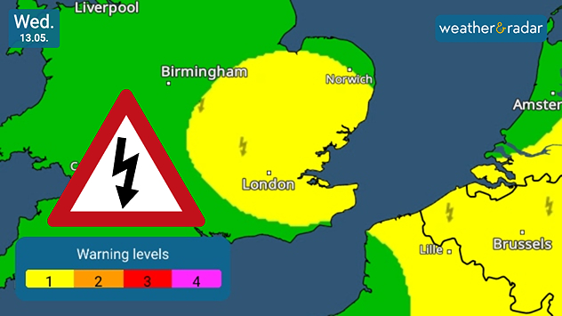
Weather warning map of southern UK showing a yellow thunderstorm alert area around London and East Anglia, with lightning icons, a warning triangle, and a color-coded alert scale on Wednesday 13.05.
The strongest signals for thunderstorms are in south-east England, but could spread wider.

Warnings for thunderstorms cover parts of England today, amid wider heavy showers, strong gusts, and a chance of hail.

South-east England sees the strongest signals for developing thunderstorms towards the afternoon, though conditions are ripe along the east coast of England, into eastern Scotland.

Showers are more widespread aside from the thundery potential too, with growing gusts making for an unpleasant mid-week for many.

The heavier showers may also deliver bouts of hailstones too as they pass through.

Meanwhile, thunderstorms are forming across eastern Europe over the Netherlands, Belgium into parts of Germany and France.

Keep an eye on the LightningRadar later on Wednesday as these thunderstorms in the UK begin to form.

Ryan Hathaway
More on the topic
Autumn arrives with vivid colour. Your weather - Your shots. . . Sunday, 6 September 2026
Split image showing peach-lit textured clouds above silhouetted trees and golden cumulus clouds reflected in a calm canal lined with boats.
Sunday, 6 September 2026

Your weather - Your shots

Autumn arrives with vivid colour
Hottest summer on record for Ireland. Beating 2025's record. . . Thursday, 3 September 2026
Temperature map of Ireland showing 29°C in Dublin, 26°C in Cork, 24°C in Belfast, and 23°C in Galway, with a red thermometer icon.
Thursday, 3 September 2026

Beating 2025's record

Hottest summer on record for Ireland
A generally gusty Thursday. Moderate but notable wind. . . Wednesday, 2 September 2026
Wind forecast showing widespread 25-30 mph winds across the UK and Ireland, including Glasgow, Dublin, Cork, Cardiff, and London, with a windsock symbol.
Wednesday, 2 September 2026

Moderate but notable wind

A generally gusty Thursday
All weather news
This might also interest you
New records for England and Wales. Broken again tomorrow?. . . Thursday, 25 June 2026
Temperature map of southwest Britain on 25.06 showing extreme heat across southern Wales and southwest England, with Bute Park in Cardiff highlighted at 34.2°C and Yeovilton at 36.4°C amid widespread deep red heat zones.
Thursday, 25 June 2026

Broken again tomorrow?

New records for England and Wales
Storm Chandra makes impact. Severe gales & heavy rain. . . Tuesday, 27 January 2026
Split image showing strong winds over the UK on a forecast map and widespread rain and snow on a weather radar map.
Tuesday, 27 January 2026

Severe gales & heavy rain

Storm Chandra makes impact
A stormy week in the skies above. Your weather - Your shots. . . Sunday, 30 August 2026
Split image showing lightning branching beneath dark storm clouds above rooftops on the left and an orange-pink sunset over a calm sea on the right.
Sunday, 30 August 2026

Your weather - Your shots

A stormy week in the skies above
All articles
Weather & Radar

Weather & Radar is also available on

Google Play StoreApp Store

Company

Contact us Privacy Policy Legal info Accessibility statement

Services

Uploader

Socials

facebooktwittertikToklinkList