Home
Weather London
WeatherRadar
RainfallRadar
TemperatureRadar
WindRadar
LightningRadar
Weather News
Editor's Pick
Discover the app
Weather widget
Contact us
Apps
Career
    Home / Editor's Pick /

    Gusty in the UK & Ireland: Storms bring warmth to Europe

23:00
4 December 2025

Gusty in the UK & Ireland
Storms will soon bring spring air

At the beginning of next week, very mild air will reach us with temperatures more reminiscent of spring than winter.

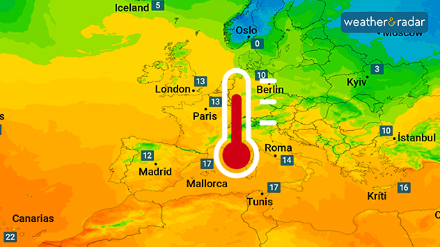
Temperatures across much of Europe are set to rise significantly again in the near future, thanks to storm fronts over the Atlantic reaching the UK and Ireland.

These will draw in very mild air from the weekend onwards and direct it straight towards Europe from Friday, with strong winds across the two countries.

Already noticeably milder in south-western EuropeTemperature radar for Saturday

At the start of the second week of December, temperatures in Central Europe will reach 10 to 15 degrees Celsius. In South-Western Europe, it will be warm, with temperatures ranging from 15 to 20 degrees Celsius.

In some areas, such as the Spanish Mediterranean coast, peak temperatures may even exceed these levels.

As things stand at present, the spring-like air is likely to remain in many regions throughout the week.

Barcelona

We
23
33
Th
23
33
Fr
23
32
Sa
23
32
Su
24
33
Mo
25
32
Tu
26
34
We
27
35
Th
27
35
Fr
26
34
Sa
26
34
Su
26
34
Mo
25
33
Tu
25
33
Max (°C)
Min (°C)
moreless

Paris

We
18
38
Th
21
31
Fr
19
29
Sa
18
29
Su
19
34
Mo
23
35
Tu
21
31
We
21
31
Th
19
30
Fr
19
27
Sa
17
26
Su
17
25
Mo
17
27
Tu
15
28
Max (°C)
Min (°C)
moreless

Frankfurt

We
16
35
Th
17
37
Fr
19
33
Sa
20
29
Su
19
33
Mo
21
33
Tu
21
30
We
22
30
Th
20
30
Fr
20
28
Sa
17
25
Su
16
25
Mo
17
25
Tu
16
26
Max (°C)
Min (°C)
moreless

London

We
19
33
Th
19
27
Fr
16
25
Sa
16
26
Su
16
28
Mo
20
30
Tu
18
26
We
18
26
Th
17
25
Fr
16
25
Sa
17
25
Su
16
24
Mo
17
25
Tu
16
26
Max (°C)
Min (°C)
moreless

Dublin

We
17
23
Th
11
20
Fr
10
20
Sa
9
19
Su
8
19
Mo
14
21
Tu
11
19
We
12
20
Th
10
18
Fr
11
20
Sa
12
20
Su
12
20
Mo
13
21
Tu
13
21
Max (°C)
Min (°C)
moreless
Dr. Bernd Maurer
Ryan Hathaway
More on the topic
Catastrophic forest fires in Europe. Thousands evacuated. . . Monday, 27 July 2026
A composite image showing a temperature map of south-western Europe and a drone shot of a forest fire near Cap Ferret. A warning symbol featuring a flame indicates the increased risk of forest fires.
Monday, 27 July 2026

Thousands evacuated

Catastrophic forest fires in Europe
Clouds return to capture the scene. Your weather - Your shots. . . Sunday, 26 July 2026
Waxing crescent Moon above vivid pink and magenta sunset clouds, with silhouetted trees along the horizon beneath a deepening blue twilight sky.
Sunday, 26 July 2026

Your weather - Your shots

Clouds return to capture the scene
Fourth heatwave of the year. Peaking Wednesday. . . Tuesday, 28 July 2026
Temperature map of England and Wales on Wednesday 29.07 showing widespread hot conditions, with temperatures reaching 33°C near Cambridge, 32°C around London, Norwich, and Southend-on-Sea, and a large heat warning symbol highlighting elevated heat risk.
Tuesday, 28 July 2026

Peaking Wednesday

Fourth heatwave of the year
All weather news
This might also interest you
Super Typhoon Bavi threatens Taiwan. Up to 1,000 mm of rain. . . Wednesday, 8 July 2026
The image shows an intense tropical cyclone over the western Pacific, east of Taiwan and the Philippines. The centre of the system is depicted as a light purple and white vortex with a clearly visible eye, surrounded by a ring of red and orange areas indicating the strongest wind speeds. A white arrow marks the typhoon’s predicted track towards the north-west, in the direction of Taiwan. To the west of the storm lie the Philippines, with the cities of Manila and Cebu; to the north of these lies Taiwan, with Taipei. Further west, the Chinese coast, including Hong Kong, and parts of Vietnam can be seen. The coloured wind map shows predominantly green areas outside the storm’s core, indicating significantly weaker winds. White streamlines illustrate the typhoon’s anti-clockwise circulation in the Northern Hemisphere. The highest wind speeds are concentrated around the eye of the cyclone.
Wednesday, 8 July 2026

Up to 1,000 mm of rain

Super Typhoon Bavi threatens Taiwan
Storm Chandra makes impact. Severe gales & heavy rain. . . Tuesday, 27 January 2026
Split image showing strong winds over the UK on a forecast map and widespread rain and snow on a weather radar map.
Tuesday, 27 January 2026

Severe gales & heavy rain

Storm Chandra makes impact
Seasonal warmth between spring thunder. Your weather - Your shots. . . Sunday, 19 April 2026
Split image showing coastal sunset with layered lenticular clouds over rooftops and palm trees on the left, and a green valley with river and hills under soft daylight on the right.
Sunday, 19 April 2026

Your weather - Your shots

Seasonal warmth between spring thunder
All articles
Weather & Radar

Weather & Radar is also available on

Google Play StoreApp Store

Company

Contact us Privacy Policy Legal info Accessibility statement

Services

Uploader

Socials

facebooktwittertikToklinkList