Home
Weather London
WeatherRadar
RainfallRadar
TemperatureRadar
WindRadar
LightningRadar
Weather News
Editor's Pick
Discover the app
Weather widget
Contact us
Apps
Career
    Home / Editor's Pick /

    Gusty conditions ahead - Low pressure influences coming days

14:00
12 May 2026

Gusty conditions ahead
Low pressure brings windy days

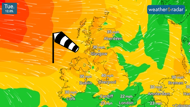
Feel the cooling gusts today as trees wave in the air? The coming days are punctuated by stronger winds across the UK and Ireland.

On Tuesday, gusts reach highs of around 40 mph in north-west England, before intensifying slightly into Wednesday to slightly higher gusts of 45 mph (72 km/h) in the same area, and spreading across Ireland.

The cause is an area of low-pressure situated in the North Sea, by Thursday this moves into Norway as gusts begin to ease.

Whilst it is out at sea however, its position is drawing cooler air into the UK and Ireland, dropping daily highs below average for the time of year.

Ryan Hathaway

More on the topic

Gloomy evening with a few spots of rain. Bonfire Night. . . Thursday, 5 November 2026
Split image showing a cloudy UK weather map with temperatures of 8–9°C alongside colourful fireworks bursting through smoke in the night sky.
Thursday, 5 November 2026

Bonfire Night

Gloomy evening with a few spots of rain
Summer heat in the middle of November. Unusual temperatures. . . Tuesday, 10 November 2026
The weather map shows the temperatures in south-eastern Europe and the Mediterranean region. It is particularly warm in the Balkans: temperatures in Belgrade are reaching 25 degrees. A red arrow indicates that warm air is flowing from the central Mediterranean towards Serbia. In Italy, Greece and Romania, too, temperatures are above 20 degrees in many places. By contrast, it is significantly cooler in the Alps and in parts of Central Europe.
Tuesday, 10 November 2026

Unusual temperatures

Summer heat in the middle of November
Further fog disruption expected. Growing dense overnight. . . Monday, 9 November 2026
Weather map showing widespread fog across the English Midlands, with a red fog warning symbol near Nottingham and temperatures of 4–6°C.
Monday, 9 November 2026

Growing dense overnight

Further fog disruption expected
All weather news

This might also interest you

Flooding, gales, and heavy snow. Storm Chandra. . . Tuesday, 27 January 2026
Split image showing aerial flooding in a town with muddy water covering roads on the left, and a rural road on the right blocked by heavy snowfall with vans stopped and a person walking in snow.
Tuesday, 27 January 2026

Storm Chandra

Flooding, gales, and heavy snow
Seasonal warmth between spring thunder. Your weather - Your shots. . . Sunday, 19 April 2026
Split image showing coastal sunset with layered lenticular clouds over rooftops and palm trees on the left, and a green valley with river and hills under soft daylight on the right.
Sunday, 19 April 2026

Your weather - Your shots

Seasonal warmth between spring thunder
A stormy week in the skies above. Your weather - Your shots. . . Sunday, 30 August 2026
Split image showing lightning branching beneath dark storm clouds above rooftops on the left and an orange-pink sunset over a calm sea on the right.
Sunday, 30 August 2026

Your weather - Your shots

A stormy week in the skies above
All articles
Weather & Radar

Weather & Radar is also available on

Google Play StoreApp Store

Company

Contact us Privacy Policy Legal info Accessibility statement

Services

Uploader

Socials

facebooktwittertikToklinkList