Home
Weather London
WeatherRadar
RainfallRadar
TemperatureRadar
WindRadar
LightningRadar
Weather News
Editor's Pick
Discover the app
Weather widget
Contact us
Apps
Career
    Home / Editor's Pick /

    Gusts up to 65 mph - Storm approaching the UK and Ireland

09:00
28 August 2025

Gusts up to 65 mph
Storm approaching the UK and Ireland

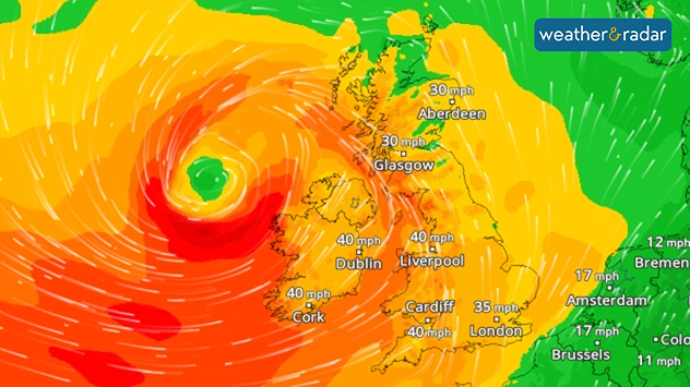
Wind radar showing stormy weather and strong gusts of wind over Ireland and Great Britain.
WindRadar: A powerful storm front will sweep across the UK and Ireland over the weekend.

The next few days will be stormy once again. Ex-Hurricane Erin is currently bringing strong gusts of wind. On Saturday, the next storm front will arrive from the Atlantic.

Then, especially on the west coast of Ireland, gusts of up to 65 mph (100 km/h) are possible. Strong winds of up to 50 mph will also blow in England, Wales, and Scotland, with stronger gusts at higher altitudes.

The storm will only weaken at the start of next week and move off to the northeast.

Stormy times in the UKWindRadar
Dennis Oswald
Ryan Hathaway
More on the topic
Heat map centered on London showing intense red temperatures across southeast England, with Heathrow highlighted at 33.5°C and nearby cities around 30–32°C.
Monday, 25 May 2026

33.5 °C and still rising

Hottest May day on record
Temperature map of southeast England showing overnight low temperatures, with Kenley highlighted at 21.3°C and surrounding areas in yellow-orange shades indicating mild nighttime conditions.
Tuesday, 26 May 2026

May heatwave

Tropical night breaks overnight record
A composite image showing the Temperature Radar and a drinking fountain. The Temperature Radar shows Thursday’s maximum temperatures of up to 37.8 degrees in France, whilst people use a fountain to cool off.
Friday, 29 May 2026

Up to 38 °C in France

Heatwave clocks more record temperatures
All weather news
This might also interest you
Illustration of white and yellow fireworks on a blue background.
Wednesday, 31 December 2025

Hello 2026

Happy New Year
Split image showing aerial flooding in a town with muddy water covering roads on the left, and a rural road on the right blocked by heavy snowfall with vans stopped and a person walking in snow.
Tuesday, 27 January 2026

Storm Chandra

Flooding, gales, and heavy snow
Outline of Santa Claus with a yellow and white hat, "Ho-Ho-Ho" next to the outline above a Christmas tree.
Thursday, 25 December 2025

Merry Christmas!

Wishes from Weather & Radar
All articles
Weather & Radar

Weather & Radar is also available on

Google Play StoreApp Store

Company

Contact us Privacy Policy Legal info Accessibility statement

Services

Uploader

Socials

facebooktwittertikToklinkList