Home
Weather London
WeatherRadar
RainfallRadar
TemperatureRadar
WindRadar
LightningRadar
Weather News
Editor's Pick
Discover the app
Weather widget
Contact us
Apps
Career
    Home / Editor's Pick /

    Gusts of over 185 mph - Yet another typhoon in the Pacific

10:00
3 July 2026

Gusts of over 185 mph
Yet another typhoon in the Pacific

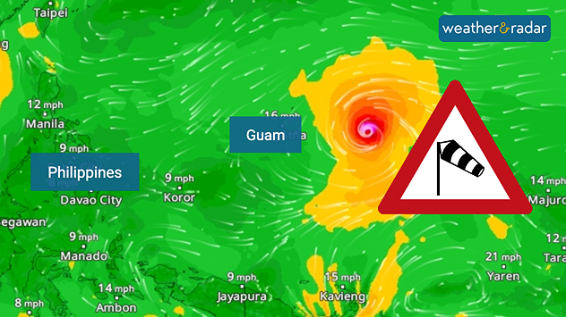
The next typhoon is already forming in the Pacific, named Bavi, the system could intensify into a super typhoon shortly.

Bavi even has a change at becoming the strongest typhoon ever to pass through the north-western Pacific with gusts of over 185 miles per hour possible.

Typhoon Bavi on the WindRadar.

The typhoon is still out at sea, but is heading towards the Mariana Islands and Guam. According to the forecast, the island groups will be hit from Sunday evening onwards. This would be the second typhoon to hit the region this year.

Typhoon Sinlaku struck the area as recently as April, and the clean-up work is still in full swing. Bavi is now heading towards the Philippines.

Did you know?

Terms such as hurricanes, typhoons and cyclones describe the same phenomenon in different parts of the world’s oceans. However, it is only in the north-western part of the Pacific Ocean and in Asia that cyclones are called typhoons.

One reason for the high number of powerful typhoons could be El Niño, which causes sea temperatures in the eastern Pacific to rise. During an El Niño event, the likelihood of powerful typhoons or hurricanes in the Pacific increases.

Weather & Radar editorial team
More on the topic
The solar eclipse arrives tonight. Great visibility for most. . . Wednesday, 12 August 2026
Split image showing an annular solar eclipse on the left and a UK and Ireland weather map on the right with mostly sunny skies, temperatures of 30–31°C in England and 27°C in Dublin.
Wednesday, 12 August 2026

Great visibility for most

The solar eclipse arrives tonight
Solar eclipse on Wednesday. Save the date. . . Monday, 10 August 2026
People are watching a solar eclipse. The sun is already partially obscured. Next to it is the weather radar forecast for Wednesday, showing an almost cloudless sky.
Monday, 10 August 2026

Save the date

Solar eclipse on Wednesday
Europe's summer set to to break records. Extreme heat and drought. . . Tuesday, 11 August 2026
Split image showing a European heat map with temperatures reaching 39°C in France and Spain on the left, and a severely depleted river with exposed sandy banks beneath a bridge on the right.
Tuesday, 11 August 2026

Extreme heat and drought

Europe's summer set to to break records
All weather news
This might also interest you
Turbulent weather in the Canary Islands. Storm and rain. . . Friday, 12 December 2025
Weather graphic showing rain and wind fields over the Canary Islands and a central warning symbol.
Friday, 12 December 2025

Storm and rain

Turbulent weather in the Canary Islands
Seasonal warmth between spring thunder. Your weather - Your shots. . . Sunday, 19 April 2026
Split image showing coastal sunset with layered lenticular clouds over rooftops and palm trees on the left, and a green valley with river and hills under soft daylight on the right.
Sunday, 19 April 2026

Your weather - Your shots

Seasonal warmth between spring thunder
New records for England and Wales. Broken again tomorrow?. . . Thursday, 25 June 2026
Temperature map of southwest Britain on 25.06 showing extreme heat across southern Wales and southwest England, with Bute Park in Cardiff highlighted at 34.2°C and Yeovilton at 36.4°C amid widespread deep red heat zones.
Thursday, 25 June 2026

Broken again tomorrow?

New records for England and Wales
All articles
Weather & Radar

Weather & Radar is also available on

Google Play StoreApp Store

Company

Contact us Privacy Policy Legal info Accessibility statement

Services

Uploader

Socials

facebooktwittertikToklinkList