Home
Weather London
WeatherRadar
RainfallRadar
TemperatureRadar
WindRadar
LightningRadar
Weather News
Editor's Pick
Discover the app
Weather widget
Contact us
Apps
Career
    Home / Editor's Pick /

    Gusts of over 185 mph - Yet another typhoon in the Pacific

10:00
3 July 2026

Gusts of over 185 mph
Yet another typhoon in the Pacific

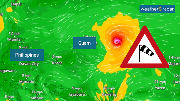
The next typhoon is already forming in the Pacific, named Bavi, the system could intensify into a super typhoon shortly.

Bavi even has a change at becoming the strongest typhoon ever to pass through the north-western Pacific with gusts of over 185 miles per hour possible.

Typhoon Bavi on the WindRadar.

The typhoon is still out at sea, but is heading towards the Mariana Islands and Guam. According to the forecast, the island groups will be hit from Sunday evening onwards. This would be the second typhoon to hit the region this year.

Typhoon Sinlaku struck the area as recently as April, and the clean-up work is still in full swing. Bavi is now heading towards the Philippines.

Did you know?

Terms such as hurricanes, typhoons and cyclones describe the same phenomenon in different parts of the world’s oceans. However, it is only in the north-western part of the Pacific Ocean and in Asia that cyclones are called typhoons.

One reason for the high number of powerful typhoons could be El Niño, which causes sea temperatures in the eastern Pacific to rise. During an El Niño event, the likelihood of powerful typhoons or hurricanes in the Pacific increases.

Weather & Radar editorial team
More on the topic
Heatwave breaks after remarkable run. Two weeks of heat. . . Monday, 20 July 2026
Split image showing the London skyline in hazy golden sunshine on the left and a July temperature anomaly map of Europe on the right, with above-average temperatures across the UK, Ireland, and much of western Europe highlighted in red alongside a thermometer icon.
Monday, 20 July 2026

Two weeks of heat

Heatwave breaks after remarkable run
Parts of England inching towards drought. Low rivers & reservoirs. . . Wednesday, 22 July 2026
People relaxing in a park during hot weather ,with one person sunbathing on dry yellow grass beneath large leafy trees under a blue sky with scattered fair-weather clouds.
Wednesday, 22 July 2026

Low rivers & reservoirs

Parts of England inching towards drought
Drought for North Wales and Upper Severn. 2% of average rainfall. . . Thursday, 23 July 2026
Split image showing a July rainfall anomaly map of Europe on the left with below-average rainfall across the UK, Ireland, and much of western and central Europe, and an active moorland wildfire on the right producing flames and thick smoke near homes.
Thursday, 23 July 2026

2% of average rainfall

Drought for North Wales and Upper Severn
All weather news
This might also interest you
Super Typhoon Bavi threatens Taiwan. Up to 1,000 mm of rain. . . Wednesday, 8 July 2026
The image shows an intense tropical cyclone over the western Pacific, east of Taiwan and the Philippines. The centre of the system is depicted as a light purple and white vortex with a clearly visible eye, surrounded by a ring of red and orange areas indicating the strongest wind speeds. A white arrow marks the typhoon’s predicted track towards the north-west, in the direction of Taiwan. To the west of the storm lie the Philippines, with the cities of Manila and Cebu; to the north of these lies Taiwan, with Taipei. Further west, the Chinese coast, including Hong Kong, and parts of Vietnam can be seen. The coloured wind map shows predominantly green areas outside the storm’s core, indicating significantly weaker winds. White streamlines illustrate the typhoon’s anti-clockwise circulation in the Northern Hemisphere. The highest wind speeds are concentrated around the eye of the cyclone.
Wednesday, 8 July 2026

Up to 1,000 mm of rain

Super Typhoon Bavi threatens Taiwan
Seasonal warmth between spring thunder. Your weather - Your shots. . . Sunday, 19 April 2026
Split image showing coastal sunset with layered lenticular clouds over rooftops and palm trees on the left, and a green valley with river and hills under soft daylight on the right.
Sunday, 19 April 2026

Your weather - Your shots

Seasonal warmth between spring thunder
New records for England and Wales. Broken again tomorrow?. . . Thursday, 25 June 2026
Temperature map of southwest Britain on 25.06 showing extreme heat across southern Wales and southwest England, with Bute Park in Cardiff highlighted at 34.2°C and Yeovilton at 36.4°C amid widespread deep red heat zones.
Thursday, 25 June 2026

Broken again tomorrow?

New records for England and Wales
All articles
Weather & Radar

Weather & Radar is also available on

Google Play StoreApp Store

Company

Contact us Privacy Policy Legal info Accessibility statement

Services

Uploader

Socials

facebooktwittertikToklinkList