Home
Weather London
WeatherRadar
RainfallRadar
TemperatureRadar
WindRadar
LightningRadar
Weather News
Editor's Pick
Discover the app
Weather widget
Contact us
Apps
Career
    Home / Editor's Pick /

    Gusts of over 185 mph - Yet another typhoon in the Pacific

10:00
3 July 2026

Gusts of over 185 mph
Yet another typhoon in the Pacific

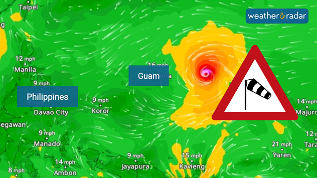
The next typhoon is already forming in the Pacific, named Bavi, the system could intensify into a super typhoon shortly.

Bavi even has a change at becoming the strongest typhoon ever to pass through the north-western Pacific with gusts of over 185 miles per hour possible.

Typhoon Bavi on the WindRadar.

The typhoon is still out at sea, but is heading towards the Mariana Islands and Guam. According to the forecast, the island groups will be hit from Sunday evening onwards. This would be the second typhoon to hit the region this year.

Typhoon Sinlaku struck the area as recently as April, and the clean-up work is still in full swing. Bavi is now heading towards the Philippines.

Did you know?

Terms such as hurricanes, typhoons and cyclones describe the same phenomenon in different parts of the world’s oceans. However, it is only in the north-western part of the Pacific Ocean and in Asia that cyclones are called typhoons.

One reason for the high number of powerful typhoons could be El Niño, which causes sea temperatures in the eastern Pacific to rise. During an El Niño event, the likelihood of powerful typhoons or hurricanes in the Pacific increases.

Weather & Radar editorial team
More on the topic
Warm waters raise severe weather risk. Mediterranean bathtub. . . Friday, 4 September 2026
Left: Map showing water temperatures in the Mediterranean; Right: Dark clouds over a stretch of Mediterranean coastline. A bolt of lightning strikes and a curtain of rain can be seen.
Friday, 4 September 2026

Mediterranean bathtub

Warm waters raise severe weather risk
Cheshire Gap produces shower funnel. Local phenomenon. . . Wednesday, 9 September 2026
Weather map showing showers moving southeast from Liverpool toward Birmingham, driven by Cheshire Gap convergence across central England.
Wednesday, 9 September 2026

Local phenomenon

Cheshire Gap produces shower funnel
A generally gusty Thursday. Moderate but notable wind. . . Wednesday, 2 September 2026
Wind forecast showing widespread 25-30 mph winds across the UK and Ireland, including Glasgow, Dublin, Cork, Cardiff, and London, with a windsock symbol.
Wednesday, 2 September 2026

Moderate but notable wind

A generally gusty Thursday
All weather news
This might also interest you
Bright and warm conditions take hold. Spring-like outlook. . . Thursday, 23 April 2026
Split UK map showing warm temperatures up to 21 degrees in orange on the left and clear sunny conditions with temperatures from 12 to 18 degrees on the right, with sun icons across the country.
Thursday, 23 April 2026

Spring-like outlook

Bright and warm conditions take hold
New records for England and Wales. Broken again tomorrow?. . . Thursday, 25 June 2026
Temperature map of southwest Britain on 25.06 showing extreme heat across southern Wales and southwest England, with Bute Park in Cardiff highlighted at 34.2°C and Yeovilton at 36.4°C amid widespread deep red heat zones.
Thursday, 25 June 2026

Broken again tomorrow?

New records for England and Wales
A stormy week in the skies above. Your weather - Your shots. . . Sunday, 30 August 2026
Split image showing lightning branching beneath dark storm clouds above rooftops on the left and an orange-pink sunset over a calm sea on the right.
Sunday, 30 August 2026

Your weather - Your shots

A stormy week in the skies above
All articles
Weather & Radar

Weather & Radar is also available on

Google Play StoreApp Store

Company

Contact us Privacy Policy Legal info Accessibility statement

Services

Uploader

Socials

facebooktwittertikToklinkList