Home
Weather London
WeatherRadar
RainfallRadar
TemperatureRadar
WindRadar
LightningRadar
Weather News
Editor's Pick
Discover the app
Weather widget
Contact us
Apps
Career
    Home / Editor's Pick /

    Gusts of 80 mph+ – Storm Floris arrives

07:00
4 August 2025

Gusts of 80 mph+
Storm Floris arrives

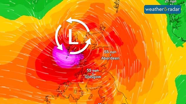
Wind map showing hurricane-level gusts from Storm Floris in western Scotland.
The WindRadar forecast shows the storm in western Scotland.

An exceptionally strong summer storm developed over the eastern Atlantic on Sunday. Today, Storm Floris has arrives in the UK.

Gusts of up to 62 mph (100 km/h) are expected in the north of Ireland. In the west of Scotland and on the Hebrides, hurricane-force gusts of up to 86 mph are expected.

Possible hazards

  • As the trees are fully leafed, there is a high probability that some trees will fall over.
  • Waves up to 6 metres high hit the coast.
  • Holidaymakers at campsites should take extra care to protect their belongings.

During the course of the day, Floris will move eastwards towards the North Sea. It will reach the west coast of Norway during the night of Tuesday. Wind speeds of up to 60 mph are possible there. On the Danish North Sea coast, gusts will reach speeds of 37 to 50 mph.

Follow Storm Floris liveWindRadar
Weather & Radar editorial team
More on the topic
A marked change in the weather. Cold front heading south. . . Monday, 7 September 2026
Map of Europe showing a cold front stretching from Scandinavia to Spain. Thunderstorms are shown in southern and central Europe.
Monday, 7 September 2026

Cold front heading south

A marked change in the weather
Cheshire Gap produces shower funnel. Local phenomenon. . . Wednesday, 9 September 2026
Weather map showing showers moving southeast from Liverpool toward Birmingham, driven by Cheshire Gap convergence across central England.
Wednesday, 9 September 2026

Local phenomenon

Cheshire Gap produces shower funnel
Hottest summer on record for Ireland. Beating 2025's record. . . Thursday, 3 September 2026
Temperature map of Ireland showing 29°C in Dublin, 26°C in Cork, 24°C in Belfast, and 23°C in Galway, with a red thermometer icon.
Thursday, 3 September 2026

Beating 2025's record

Hottest summer on record for Ireland
All weather news
This might also interest you
Flooding, gales, and heavy snow. Storm Chandra. . . Tuesday, 27 January 2026
Split image showing aerial flooding in a town with muddy water covering roads on the left, and a rural road on the right blocked by heavy snowfall with vans stopped and a person walking in snow.
Tuesday, 27 January 2026

Storm Chandra

Flooding, gales, and heavy snow
Historic Storm Éowyn arrives. On this day.... . . Saturday, 24 January 2026
Split image showing a person in a yellow jacket struggling against strong winds and heavy rain on a street at night on the left, and an Irish wind forecast map on the right with red and purple shading, gusts up to 75 mph, and a wind warning icon, divided by a curved white line.
Saturday, 24 January 2026

On this day...

Historic Storm Éowyn arrives
Bright and warm conditions take hold. Spring-like outlook. . . Thursday, 23 April 2026
Split UK map showing warm temperatures up to 21 degrees in orange on the left and clear sunny conditions with temperatures from 12 to 18 degrees on the right, with sun icons across the country.
Thursday, 23 April 2026

Spring-like outlook

Bright and warm conditions take hold
All articles
Weather & Radar

Weather & Radar is also available on

Google Play StoreApp Store

Company

Contact us Privacy Policy Legal info Accessibility statement

Services

Uploader

Socials

facebooktwittertikToklinkList