Home
Weather London
WeatherRadar
RainfallRadar
TemperatureRadar
WindRadar
LightningRadar
Weather News
Editor's Pick
Discover the app
Weather widget
Contact us
Apps
Career
    Home / Editor's Pick /

    Good visibility - Possible aurora arrives in the evening

14:07
1 September 2025

Good visibility
Possible aurora arrives in the evening

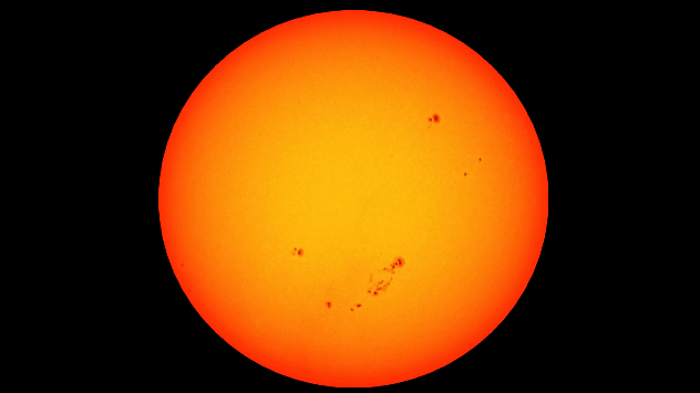
The prominent sunspots that are responsible for today's possible aurora. - © Miloslav Roháček

A plasma cloud from the sun will reach Earth tonight, triggering a moderate geomagnetic storm which could bring auroras to our skies.

A long-lasting M 2.7 flare took place on sunspot AR 4204 on Saturday evening. It ejected a cloud of electrically charged particles that is now moving through space at speeds of up to 1,000 kilometres per second.

According to the US agency NOAA's model, material from the Sun will reach our planet before midnight today. However, the deviation of this model is within a few hours.

The geomagnetic storm is expected to reach category G3, which means that we could see the aurora low over the northern horizon.

Weather outlook

After a stormy Monday, the skies clear towards the evening for parts of the UK and Ireland. With optimal visibility to be seen across much of England, and more southerly areas of Ireland.

Miloslav Roháček
Ryan Hathaway
More on the topic
Drought across large parts of Europe. High fire risk. . . Monday, 20 July 2026
Split image showing a Europe rainfall anomaly map on the left with widespread dry conditions across much of the continent, and a cracked, parched field on the right alongside a wildfire warning symbol highlighting elevated fire risk.
Monday, 20 July 2026

High fire risk

Drought across large parts of Europe
Severe damage along the Adriatic coast. Huge hail and storms. . . Wednesday, 22 July 2026
Two hands are holding huge hailstones; next to them is a weather map showing thunderstorms and frequent lightning over the Adriatic coast and the western Balkans.
Wednesday, 22 July 2026

Huge hail and storms

Severe damage along the Adriatic coast
Heat becoming a bigger factor in drought. New study. . . Thursday, 23 July 2026
A hand holds dry, dusty earth above a parched field. The ground is cracked and covered with plant debris – a sign of prolonged drought.
Thursday, 23 July 2026

New study

Heat becoming a bigger factor in drought
All weather news
This might also interest you
Bright and warm conditions take hold. Spring-like outlook. . . Thursday, 23 April 2026
Split UK map showing warm temperatures up to 21 degrees in orange on the left and clear sunny conditions with temperatures from 12 to 18 degrees on the right, with sun icons across the country.
Thursday, 23 April 2026

Spring-like outlook

Bright and warm conditions take hold
A frozen start to the weekend. Icy conditions. . . Friday, 13 February 2026
UK temperature map dated 14.02 showing widespread subzero values in blue shading, with readings such as −4 in Glasgow, −3 in Dublin, and −2 in London, alongside a blue thermometer icon.
Friday, 13 February 2026

Icy conditions

A frozen start to the weekend
Flooding, gales, and heavy snow. Storm Chandra. . . Tuesday, 27 January 2026
Split image showing aerial flooding in a town with muddy water covering roads on the left, and a rural road on the right blocked by heavy snowfall with vans stopped and a person walking in snow.
Tuesday, 27 January 2026

Storm Chandra

Flooding, gales, and heavy snow
All articles
Weather & Radar

Weather & Radar is also available on

Google Play StoreApp Store

Company

Contact us Privacy Policy Legal info Accessibility statement

Services

Uploader

Socials

facebooktwittertikToklinkList