Home
Weather London
WeatherRadar
RainfallRadar
TemperatureRadar
WindRadar
LightningRadar
Weather News
Editor's Pick
Discover the app
Weather widget
Contact us
Apps
Career
    Home / Editor's Pick /

    Gales return - Increasingly gusty into midweek

09:00
24 March 2026

Gales return
Increasingly gusty into midweek

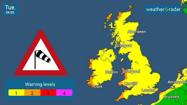
UK warning map dated Tue 24.03 showing widespread yellow wind warnings with a windsock icon and warning scale legend.
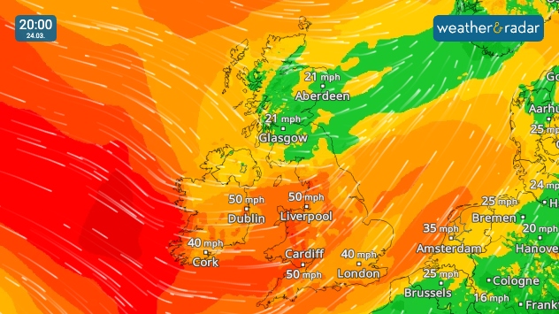
Wind forecast map at 20:00 on Tue 24.03 showing strong winds across the UK and Ireland, with gusts around 40–50 mph and strongest winds over Ireland and western Britain.
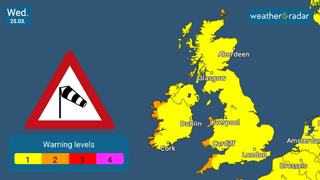
UK warning map dated Wed 25.03 showing continued yellow wind warnings across the country with a windsock symbol and warning scale.
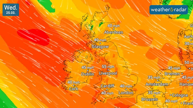
Wind forecast map dated Wed 25.03 showing widespread strong winds across the UK and Ireland, with gusts around 40–55 mph, strongest in western areas.
1/4
Wind warnings for Tuesday.

Conditions are turning, and remaining, increasingly gusty for Tuesday and Wednesday across the UK and Ireland.

Developing throughout the day on Tuesday, gusts peak around 55 mph in north-west England by Wednesday after reaching up to 50 mph by Tuesday evening around Liverpool and Cardiff.

Ireland also sees these strong gusts, with a little less intensity inland but stronger along the western coastline with up to around 60 mph (100 km/h) in the evening.

As the wind builds, the low-pressure responsible brings sweeping heavy rain over Scotland, down to northern England and Wales too.

This could result in some surface flooding, with a chance of turning wintry over higher altitudes by Wednesday morning.

Ryan Hathaway
More on the topic
Temperature map of southeast England showing overnight low temperatures, with Kenley highlighted at 21.3°C and surrounding areas in yellow-orange shades indicating mild nighttime conditions.
Tuesday, 26 May 2026

May heatwave

Tropical night breaks overnight record
Split image showing a European weather map with low-pressyre system, temperature bands, and thunderstorm icon on the left, and a bright rainbow over green countryside and mountains on the right.
Wednesday, 27 May 2026

Early summer ends

A change in the weather is on the way
A composite image showing the Temperature Radar and a drinking fountain. The Temperature Radar shows Thursday’s maximum temperatures of up to 37.8 degrees in France, whilst people use a fountain to cool off.
Friday, 29 May 2026

Up to 38 °C in France

Heatwave clocks more record temperatures
All weather news
This might also interest you
plit image showing a double rainbow over a rocky shoreline on the left and sheep grazing in a green field under stormy clouds on the right.
Sunday, 2 November 2025

Your weather - Your shots

Mixed conditions on an unsettled week
Outline of Santa Claus with a yellow and white hat, "Ho-Ho-Ho" next to the outline above a Christmas tree.
Thursday, 25 December 2025

Merry Christmas!

Wishes from Weather & Radar
Split image showing strong winds over the UK on a forecast map and widespread rain and snow on a weather radar map.
Tuesday, 27 January 2026

Severe gales & heavy rain

Storm Chandra makes impact
All articles
Weather & Radar

Weather & Radar is also available on

Google Play StoreApp Store

Company

Contact us Privacy Policy Legal info Accessibility statement

Services

Uploader

Socials

facebooktwittertikToklinkList