Home
Weather London
WeatherRadar
RainfallRadar
TemperatureRadar
WindRadar
LightningRadar
Weather News
Editor's Pick
Discover the app
Weather widget
Contact us
Apps
Career
    Home / Editor's Pick /

    Gales again - Continued warnings to start the week

16:11
14 September 2025

Gales again
Continued warnings to start the week

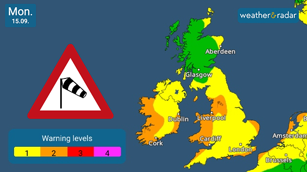
Alt text: Weather warning map for Monday, 15 September, showing wind risk levels across the UK and Ireland. Green areas indicate no warning, yellow areas (level 1) cover most of England, Wales, Northern Ireland, and southern Scotland, while orange areas (level 2) are shown in western Ireland and parts of western Wales. A wind warning symbol is displayed on the left.
Wide-ranging wind warnings for Monday.

The gusty conditions of Sunday persist into the start of the new week, with winds intensifying in places.

In-land, gusts of up to 50-55 mph are expected. There will be stronger gusts in coastal, exposed areas. While the conditions will be widespread across the UK and Ireland, Scotland will escape the worst of the day's winds.

There, gusts are only expected to reach highs of around 30 mph.

Heavy rain also returns in places, with thundery potential in north-west to northern England towards the afternoon.

Despite the conditions, the low-pressure system has not officially been named, therefore the wait for Storm Amy, and the first storm of the new season, continues.

Track current and forecasted conditionsread more
Ryan Hathaway
More on the topic
Temperature map of southeast England showing overnight low temperatures, with Kenley highlighted at 21.3°C and surrounding areas in yellow-orange shades indicating mild nighttime conditions.
Tuesday, 26 May 2026

May heatwave

Tropical night breaks overnight record
Heat map centered on London showing intense red temperatures across southeast England, with Heathrow highlighted at 33.5°C and nearby cities around 30–32°C.
Monday, 25 May 2026

33.5 °C and still rising

Hottest May day on record
Split image showing a European weather map with low-pressyre system, temperature bands, and thunderstorm icon on the left, and a bright rainbow over green countryside and mountains on the right.
Wednesday, 27 May 2026

Early summer ends

A change in the weather is on the way
All weather news
This might also interest you
Split image showing aerial flooding in a town with muddy water covering roads on the left, and a rural road on the right blocked by heavy snowfall with vans stopped and a person walking in snow.
Tuesday, 27 January 2026

Storm Chandra

Flooding, gales, and heavy snow
UK temperature map dated 14.02 showing widespread subzero values in blue shading, with readings such as −4 in Glasgow, −3 in Dublin, and −2 in London, alongside a blue thermometer icon.
Friday, 13 February 2026

Icy conditions

A frozen start to the weekend
Split UK map showing warm temperatures up to 21 degrees in orange on the left and clear sunny conditions with temperatures from 12 to 18 degrees on the right, with sun icons across the country.
Thursday, 23 April 2026

Spring-like outlook

Bright and warm conditions take hold
All articles
Weather & Radar

Weather & Radar is also available on

Google Play StoreApp Store

Company

Contact us Privacy Policy Legal info Accessibility statement

Services

Uploader

Socials

facebooktwittertikToklinkList