Home
Weather London
WeatherRadar
RainfallRadar
TemperatureRadar
WindRadar
LightningRadar
Weather News
Editor's Pick
Discover the app
Weather widget
Contact us
Apps
Career
    Home / Editor's Pick /

    Gale-force winds and storm surges: Hurricane Erin grazes the US East Coast

11:00
20 August 2025

Waves & wind batter coast
Hurricane Erin grazes US coast

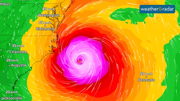
The WindRadar for Thursday afternoon shows ERIN near the coast.

Hurricane Erin continues to swirl over the Atlantic. Although it is fortunately not making landfall, the effects are clearly being felt along the US East Coast. Peak gusts of up to 100 km/h are possible, particularly around North Carolina.

Did you know?

Erin is the first hurricane of the season and even reached the highest level – category 5 – on Saturday, August 16, 2025.

A state of emergency was declared there as a precautionary measure. In North Carolina, parts of the Outer Banks – the offshore islands – had to be evacuated.

Due to the wind blowing towards the coast on the north-western side of the storm, waves several metres high and dangerous currents are expected as far north as New York. Many beaches have been closed to bathers as a precautionary measure.

Markus Müller
More on the topic
Severe weather in southern Europe. Thunderstorms & heavy rain. . . Wednesday, 9 September 2026
On the left, dark storm clouds over a coastline. On the right, a weather map shows thunderstorms over the western Mediterranean, with warning symbols for tornadoes, storms and hail.
Wednesday, 9 September 2026

Thunderstorms & heavy rain

Severe weather in southern Europe
Hurricane Lowell threatens Hawaii. Gales and flash floods. . . Tuesday, 8 September 2026
WindRadar showing Hurricane Lowell north-west of Hawaii and its well-defined storm centre.
Tuesday, 8 September 2026

Gales and flash floods

Hurricane Lowell threatens Hawaii
More rain needed to ease drought. Reservoirs still falling. . . Tuesday, 8 September 2026
Aerial view of a depleted reservoir with exposed banks and a narrow winding stream through the dry basin, surrounded by green hills and roads.
Tuesday, 8 September 2026

Reservoirs still falling

More rain needed to ease drought
All weather news
This might also interest you
Historic Storm Éowyn arrives. On this day.... . . Saturday, 24 January 2026
Split image showing a person in a yellow jacket struggling against strong winds and heavy rain on a street at night on the left, and an Irish wind forecast map on the right with red and purple shading, gusts up to 75 mph, and a wind warning icon, divided by a curved white line.
Saturday, 24 January 2026

On this day...

Historic Storm Éowyn arrives
A stormy week in the skies above. Your weather - Your shots. . . Sunday, 30 August 2026
Split image showing lightning branching beneath dark storm clouds above rooftops on the left and an orange-pink sunset over a calm sea on the right.
Sunday, 30 August 2026

Your weather - Your shots

A stormy week in the skies above
A frozen start to the weekend. Icy conditions. . . Friday, 13 February 2026
UK temperature map dated 14.02 showing widespread subzero values in blue shading, with readings such as −4 in Glasgow, −3 in Dublin, and −2 in London, alongside a blue thermometer icon.
Friday, 13 February 2026

Icy conditions

A frozen start to the weekend
All articles
Weather & Radar

Weather & Radar is also available on

Google Play StoreApp Store

Company

Contact us Privacy Policy Legal info Accessibility statement

Services

Uploader

Socials

facebooktwittertikToklinkList