Home
Weather London
WeatherRadar
RainfallRadar
TemperatureRadar
WindRadar
LightningRadar
Weather News
Editor's Pick
Discover the app
Weather widget
Contact us
Apps
Career
    Home / Editor's Pick /

    Gale-force winds and storm surges: Hurricane Erin grazes the US East Coast

11:00
20 August 2025

Waves & wind batter coast
Hurricane Erin grazes US coast

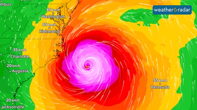
The WindRadar for Thursday afternoon shows ERIN near the coast.

Hurricane Erin continues to swirl over the Atlantic. Although it is fortunately not making landfall, the effects are clearly being felt along the US East Coast. Peak gusts of up to 100 km/h are possible, particularly around North Carolina.

Did you know?

Erin is the first hurricane of the season and even reached the highest level – category 5 – on Saturday, August 16, 2025.

A state of emergency was declared there as a precautionary measure. In North Carolina, parts of the Outer Banks – the offshore islands – had to be evacuated.

Due to the wind blowing towards the coast on the north-western side of the storm, waves several metres high and dangerous currents are expected as far north as New York. Many beaches have been closed to bathers as a precautionary measure.

Markus Müller
More on the topic
Weather warning map of Wales and western Britain showing a yellow thunderstorm alert with lightning symbols, alongside a large warning triangle for lightning.
Wednesday, 27 May 2026

Wales & western England

Thunderstorm watch continues
A composite image showing the Temperature Radar and a drinking fountain. The Temperature Radar shows Thursday’s maximum temperatures of up to 37.8 degrees in France, whilst people use a fountain to cool off.
Friday, 29 May 2026

Up to 38 °C in France

Heatwave clocks more record temperatures
v
Thursday, 28 May 2026

Gusts exceeding 124 mph

Typhoon risk in the Western Pacific
All weather news
This might also interest you
Outline of Santa Claus with a yellow and white hat, "Ho-Ho-Ho" next to the outline above a Christmas tree.
Thursday, 25 December 2025

Merry Christmas!

Wishes from Weather & Radar
Weather graphic showing rain and wind fields over the Canary Islands and a central warning symbol.
Friday, 12 December 2025

Storm and rain

Turbulent weather in the Canary Islands
Split UK map showing warm temperatures up to 21 degrees in orange on the left and clear sunny conditions with temperatures from 12 to 18 degrees on the right, with sun icons across the country.
Thursday, 23 April 2026

Spring-like outlook

Bright and warm conditions take hold
All articles
Weather & Radar

Weather & Radar is also available on

Google Play StoreApp Store

Company

Contact us Privacy Policy Legal info Accessibility statement

Services

Uploader

Socials

facebooktwittertikToklinkList