Home
Weather London
WeatherRadar
RainfallRadar
TemperatureRadar
WindRadar
LightningRadar
Weather News
Editor's Pick
Discover the app
Weather widget
Contact us
Apps
Career
    Home / Editor's Pick /

    Front on the move - Rain pushing east, risk of thunderstorms

08:00
27 August 2025

Front on the move
Rain pushing east, risk of thunderstorms

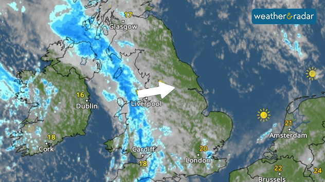
Weather map showing the UK and Ireland with a band of rain stretching from north-west Scotland down through Liverpool and Cardiff towards south Wales. Temperatures range from 16°C in Dublin to 20°C in London and 21–24°C across parts of Europe. Clearer skies with sunshine are visible over the south-east of England and mainland Europe.
A wide-ranging band of rain moves through the UK Wednesday.

Rain is currently sweeping eastwards through the UK via a front associated with ex-hurricane Erin.

Initially passing through Ireland early Wednesday morning, this band of rain continues east through the day, with heavy downpours at times.

Towards the afternoon, conditions are ripe for the potential outbreak of thunderstorms. Keep an eye on the WeatherRadar for the latest view.

Ex-hurricane influences conditionsread more
Ryan Hathaway
More on the topic
A composite image showing the Temperature Radar and a drinking fountain. The Temperature Radar shows Thursday’s maximum temperatures of up to 37.8 degrees in France, whilst people use a fountain to cool off.
Friday, 29 May 2026

Up to 38 °C in France

Heatwave clocks more record temperatures
v
Thursday, 28 May 2026

Gusts exceeding 124 mph

Typhoon risk in the Western Pacific
Split image showing a European weather map with low-pressyre system, temperature bands, and thunderstorm icon on the left, and a bright rainbow over green countryside and mountains on the right.
Wednesday, 27 May 2026

Early summer ends

A change in the weather is on the way
All weather news
This might also interest you
Split UK map showing warm temperatures up to 21 degrees in orange on the left and clear sunny conditions with temperatures from 12 to 18 degrees on the right, with sun icons across the country.
Thursday, 23 April 2026

Spring-like outlook

Bright and warm conditions take hold
Split image showing coastal sunset with layered lenticular clouds over rooftops and palm trees on the left, and a green valley with river and hills under soft daylight on the right.
Sunday, 19 April 2026

Your weather - Your shots

Seasonal warmth between spring thunder
Illustration of white and yellow fireworks on a blue background.
Wednesday, 31 December 2025

Hello 2026

Happy New Year
All articles
Weather & Radar

Weather & Radar is also available on

Google Play StoreApp Store

Company

Contact us Privacy Policy Legal info Accessibility statement

Services

Uploader

Socials

facebooktwittertikToklinkList