Home
Weather London
WeatherRadar
RainfallRadar
TemperatureRadar
WindRadar
LightningRadar
Weather News
Editor's Pick
Discover the app
Weather widget
Contact us
Apps
Career
    Home / Editor's Pick /

    Fresh storm front - Severe flooding in Spain and Portugal

07:56
5 February 2026

Fresh storm front
Severe flooding in Spain and Portugal

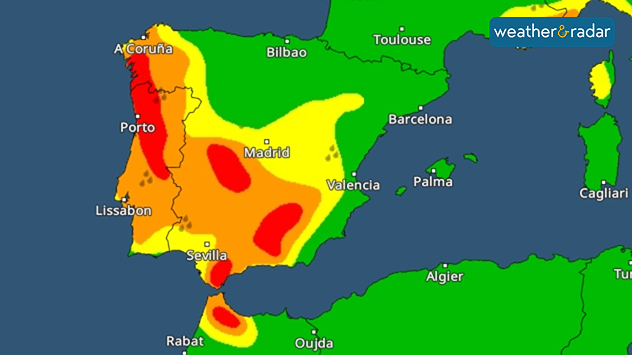
Severe weather warnings for heavy rain are in place for large parts of Portugal and Spain.

Extremely heavy rain has caused flooding in parts of Spain and Portugal. In Andalusia, more than 3,000 people had to leave their homes.

Storm Leonardo mainly affected the region of Andalusia. After hours of heavy rain, numerous rivers burst their banks, triggering landslides, and flooding.

In the municipality of Ubrique in the Andalusian province of Cádiz, the torrential rain even triggered a rockslide. A building and a car were damaged, but fortunately no one was injured.

Privacy Policy

Previously, enormous amounts of rain, nearly 300 mm, had fallen in the region of southern Spain, already amounting to around half of last year's total rainfall.

As the WeatherRadar shows, further rainfall is on the way. However, as the ground is now saturated, it cannot absorb any more rainwater. Therefore, there is no sign of the flood situation easing in the affected regions for the time being.

In addition to Andalusia, parts of Portugal have also been affected by the stormy rainfall caused by the Leonardo low-pressure system.

There will also be very strong winds with storm gusts from the Atlantic to the Balearic Islands. Metre-high waves are also expected in the Mediterranean.

Weather & Radar editorial team
More on the topic
Autumn arrives with vivid colour. Your weather - Your shots. . . Sunday, 6 September 2026
Split image showing peach-lit textured clouds above silhouetted trees and golden cumulus clouds reflected in a calm canal lined with boats.
Sunday, 6 September 2026

Your weather - Your shots

Autumn arrives with vivid colour
Cheshire Gap produces shower funnel. Local phenomenon. . . Wednesday, 9 September 2026
Weather map showing showers moving southeast from Liverpool toward Birmingham, driven by Cheshire Gap convergence across central England.
Wednesday, 9 September 2026

Local phenomenon

Cheshire Gap produces shower funnel
A generally gusty Thursday. Moderate but notable wind. . . Wednesday, 2 September 2026
Wind forecast showing widespread 25-30 mph winds across the UK and Ireland, including Glasgow, Dublin, Cork, Cardiff, and London, with a windsock symbol.
Wednesday, 2 September 2026

Moderate but notable wind

A generally gusty Thursday
All weather news
This might also interest you
Bright and warm conditions take hold. Spring-like outlook. . . Thursday, 23 April 2026
Split UK map showing warm temperatures up to 21 degrees in orange on the left and clear sunny conditions with temperatures from 12 to 18 degrees on the right, with sun icons across the country.
Thursday, 23 April 2026

Spring-like outlook

Bright and warm conditions take hold
Storm Chandra makes impact. Severe gales & heavy rain. . . Tuesday, 27 January 2026
Split image showing strong winds over the UK on a forecast map and widespread rain and snow on a weather radar map.
Tuesday, 27 January 2026

Severe gales & heavy rain

Storm Chandra makes impact
Seasonal warmth between spring thunder. Your weather - Your shots. . . Sunday, 19 April 2026
Split image showing coastal sunset with layered lenticular clouds over rooftops and palm trees on the left, and a green valley with river and hills under soft daylight on the right.
Sunday, 19 April 2026

Your weather - Your shots

Seasonal warmth between spring thunder
All articles
Weather & Radar

Weather & Radar is also available on

Google Play StoreApp Store

Company

Contact us Privacy Policy Legal info Accessibility statement

Services

Uploader

Socials

facebooktwittertikToklinkList