Home
Weather London
WeatherRadar
RainfallRadar
TemperatureRadar
WindRadar
LightningRadar
Weather News
Editor's Pick
Discover the app
Weather widget
Contact us
Apps
Career
    Home / Editor's Pick /

    For two days in a row - Hottest day ever recorded

14:45
24 July 2024

For two days in a row
Hottest day ever recorded

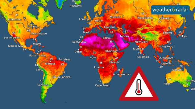
TemperatureRadar on Monday 22nd July, the hottest day recorded so far.

Sunday 21st July was the hottest day ever recorded on earth, repeated again on Monday 22nd July.

On Sunday 21st July, a staggering temperature record was broken. The world recorded an average air surface temperature of 17.09°C, shattered just 24 hours later on Monday 22nd July with 17.15°C.

These records were broken according to preliminary data from the Copernicus Climate Change Service, making it the hottest days on record since 1940.

While conditions may not have been hot locally for us across the UK and Ireland, sweltering heatwaves were engulfing many parts of the globe including Japan, China, the US and large swathes of southern Europe.

2024's heat may depend on ENSO

Every month over the last 13 consecutive months has become the hottest month since records began.

It so far seems plausible given the months so far that it could be another record-breaking year, but 2024's temperatures will depend on the intensity of when and how strongly La Niña develops.

Hottest June on record for 2024read more
More on the topic
A composite image showing the Temperature Radar and a drinking fountain. The Temperature Radar shows Thursday’s maximum temperatures of up to 37.8 degrees in France, whilst people use a fountain to cool off.
Friday, 29 May 2026

Up to 38 °C in France

Heatwave clocks more record temperatures
v
Thursday, 28 May 2026

Gusts exceeding 124 mph

Typhoon risk in the Western Pacific
Split image showing a European weather map with low-pressyre system, temperature bands, and thunderstorm icon on the left, and a bright rainbow over green countryside and mountains on the right.
Wednesday, 27 May 2026

Early summer ends

A change in the weather is on the way
All weather news
This might also interest you
Split image showing a person in a yellow jacket struggling against strong winds and heavy rain on a street at night on the left, and an Irish wind forecast map on the right with red and purple shading, gusts up to 75 mph, and a wind warning icon, divided by a curved white line.
Saturday, 24 January 2026

On this day...

Historic Storm Éowyn arrives
UK temperature map dated 14.02 showing widespread subzero values in blue shading, with readings such as −4 in Glasgow, −3 in Dublin, and −2 in London, alongside a blue thermometer icon.
Friday, 13 February 2026

Icy conditions

A frozen start to the weekend
plit image showing a double rainbow over a rocky shoreline on the left and sheep grazing in a green field under stormy clouds on the right.
Sunday, 2 November 2025

Your weather - Your shots

Mixed conditions on an unsettled week
All articles
Weather & Radar

Weather & Radar is also available on

Google Play StoreApp Store

Company

Contact us Privacy Policy Legal info Accessibility statement

Services

Uploader

Socials

facebooktwittertikToklinkList