Home
Weather London
WeatherRadar
RainfallRadar
TemperatureRadar
WindRadar
LightningRadar
Weather News
Editor's Pick
Discover the app
Weather widget
Contact us
Apps
Career
    Home / Editor's Pick /

    Flood alerts as severe weather continues

10:00
26 September 2024

Downpours & thunderstorms
Flood alerts as severe weather continues

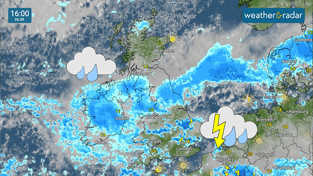
Weather radar of the UK and Ireland showing heavy rain and thunderstorms.
Heavy rain and thunderstorms on the WeatherRadar Thursday afternoon.

Flood warnings stretch across the UK as heavy rain continues to fall, building on significant rainfall earlier in the week.

A total of 99 warnings and alerts are currently live, running from Bournemouth to Newcastle. Much of the day's rain is concentrated in the north of England while heavy downpours could develop further south.

Flood warnings

Flood warnings and alerts are updated throughout the day. The number in effect may have risen or fallen since this time. 

Those heavy spells around London and in East Anglia have potential to turn thundery by this afternoon and builds on flooding earlier in the week.

Some areas saw 24 hours of rainfall surpassing the monthly average amounts, causing disruption to train lines, road travel, and the development of surface flooding amid rivers breaching their banks.

Heavy and persistent rain also remains in place over Ireland throughout Thursday before easing into Friday morning, where the downpours continue across east to south-east England.

Saturated soils after recent rainfall makes flooding more likely. Keep an eye on developments around you with the WeatherRadar.

How to activate severe weather warningsread more
Ryan Hathaway

More on the topic

Overnight impacts as Austen hits. Power cuts, travel issues. . . Friday, 23 October 2026
Split image showing floodwater surging beneath a railway bridge at night and a wind map with low pressure over the English Channel and 60 mph near Brest.
Friday, 23 October 2026

Power cuts, travel issues

Overnight impacts as Austen hits
Warnings live across the UK and Ireland. How do they work?. . . Tuesday, 20 October 2026
Weather warning map showing yellow and orange wind alerts across Ireland and England, with red level 3 areas in southwest England and a windsock symbol.
Tuesday, 20 October 2026

How do they work?

Warnings live across the UK and Ireland
Storm Boelo named. Weekend impacts. . . Thursday, 22 October 2026
Split weather maps showing Storm Boelo northwest of Scotland, winds reaching 50 mph near Glasgow and Liverpool, and spiralling Atlantic rain bands.
Thursday, 22 October 2026

Weekend impacts

Storm Boelo named
All weather news

This might also interest you

Storm Chandra makes impact. Severe gales & heavy rain. . . Tuesday, 27 January 2026
Split image showing strong winds over the UK on a forecast map and widespread rain and snow on a weather radar map.
Tuesday, 27 January 2026

Severe gales & heavy rain

Storm Chandra makes impact
A stormy week in the skies above. Your weather - Your shots. . . Sunday, 30 August 2026
Split image showing lightning branching beneath dark storm clouds above rooftops on the left and an orange-pink sunset over a calm sea on the right.
Sunday, 30 August 2026

Your weather - Your shots

A stormy week in the skies above
Long-term trends need a pinch of salt. 40 °C in July?. . . Tuesday, 30 June 2026
Temperature radar of 2022 heatwave where the all-time temperature record in the UK was set. Warning symbol overlain.
Tuesday, 30 June 2026

40 °C in July?

Long-term trends need a pinch of salt
All articles
Weather & Radar

Weather & Radar is also available on

Google Play StoreApp Store

Company

Contact us Privacy Policy Legal info Accessibility statement

Services

Uploader

Socials

facebooktwittertikToklinkList