Home
Weather London
WeatherRadar
RainfallRadar
TemperatureRadar
WindRadar
LightningRadar
Weather News
Editor's Pick
Discover the app
Weather widget
Contact us
Apps
Career
    Home / Editor's Pick /

    Flood alerts as severe weather continues

10:00
26 September 2024

Downpours & thunderstorms
Flood alerts as severe weather continues

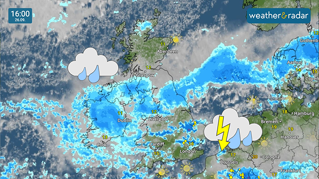
Weather radar of the UK and Ireland showing heavy rain and thunderstorms.
Heavy rain and thunderstorms on the WeatherRadar Thursday afternoon.

Flood warnings stretch across the UK as heavy rain continues to fall, building on significant rainfall earlier in the week.

A total of 99 warnings and alerts are currently live, running from Bournemouth to Newcastle. Much of the day's rain is concentrated in the north of England while heavy downpours could develop further south.

Flood warnings

Flood warnings and alerts are updated throughout the day. The number in effect may have risen or fallen since this time. 

Those heavy spells around London and in East Anglia have potential to turn thundery by this afternoon and builds on flooding earlier in the week.

Some areas saw 24 hours of rainfall surpassing the monthly average amounts, causing disruption to train lines, road travel, and the development of surface flooding amid rivers breaching their banks.

Heavy and persistent rain also remains in place over Ireland throughout Thursday before easing into Friday morning, where the downpours continue across east to south-east England.

Saturated soils after recent rainfall makes flooding more likely. Keep an eye on developments around you with the WeatherRadar.

How to activate severe weather warningsread more
Ryan Hathaway
More on the topic
Fourth heatwave of the year. Peaking Wednesday. . . Tuesday, 28 July 2026
Temperature map of England and Wales on Wednesday 29.07 showing widespread hot conditions, with temperatures reaching 33°C near Cambridge, 32°C around London, Norwich, and Southend-on-Sea, and a large heat warning symbol highlighting elevated heat risk.
Tuesday, 28 July 2026

Peaking Wednesday

Fourth heatwave of the year
Floods and landslides in parts of Asia. An unusual monsoon. . . Wednesday, 29 July 2026
Split image: On the left, flooded villages and fields can be seen in a vast landscape. On the right, a weather map of India shows heavy rainfall, along with a warning sign featuring a car in floodwater.
Wednesday, 29 July 2026

An unusual monsoon

Floods and landslides in parts of Asia
Heavier rainfall over the week for some. Ireland & Scotland. . . Tuesday, 28 July 2026
Split image showing a Europe rainfall accumulation forecast map on the left with the highest totals across the UK, Ireland, and Scandinavia, and a satellite weather map on the right with a broad band of rain stretching across Ireland, Scotland, and northern Britain, highlighted by a rain cloud icon.
Tuesday, 28 July 2026

Ireland & Scotland

Heavier rainfall over the week for some
All weather news
This might also interest you
Super Typhoon Bavi threatens Taiwan. Up to 1,000 mm of rain. . . Wednesday, 8 July 2026
The image shows an intense tropical cyclone over the western Pacific, east of Taiwan and the Philippines. The centre of the system is depicted as a light purple and white vortex with a clearly visible eye, surrounded by a ring of red and orange areas indicating the strongest wind speeds. A white arrow marks the typhoon’s predicted track towards the north-west, in the direction of Taiwan. To the west of the storm lie the Philippines, with the cities of Manila and Cebu; to the north of these lies Taiwan, with Taipei. Further west, the Chinese coast, including Hong Kong, and parts of Vietnam can be seen. The coloured wind map shows predominantly green areas outside the storm’s core, indicating significantly weaker winds. White streamlines illustrate the typhoon’s anti-clockwise circulation in the Northern Hemisphere. The highest wind speeds are concentrated around the eye of the cyclone.
Wednesday, 8 July 2026

Up to 1,000 mm of rain

Super Typhoon Bavi threatens Taiwan
A frozen start to the weekend. Icy conditions. . . Friday, 13 February 2026
UK temperature map dated 14.02 showing widespread subzero values in blue shading, with readings such as −4 in Glasgow, −3 in Dublin, and −2 in London, alongside a blue thermometer icon.
Friday, 13 February 2026

Icy conditions

A frozen start to the weekend
Seasonal warmth between spring thunder. Your weather - Your shots. . . Sunday, 19 April 2026
Split image showing coastal sunset with layered lenticular clouds over rooftops and palm trees on the left, and a green valley with river and hills under soft daylight on the right.
Sunday, 19 April 2026

Your weather - Your shots

Seasonal warmth between spring thunder
All articles
Weather & Radar

Weather & Radar is also available on

Google Play StoreApp Store

Company

Contact us Privacy Policy Legal info Accessibility statement

Services

Uploader

Socials

facebooktwittertikToklinkList