Home
Weather London
WeatherRadar
RainfallRadar
TemperatureRadar
WindRadar
LightningRadar
Weather News
Editor's Pick
Discover the app
Weather widget
Contact us
Apps
Career
    Home / Editor's Pick /

    First major storm of the season - Storm Austen named

10:00
20 October 2026

Storm Austen named
First major storm of the season

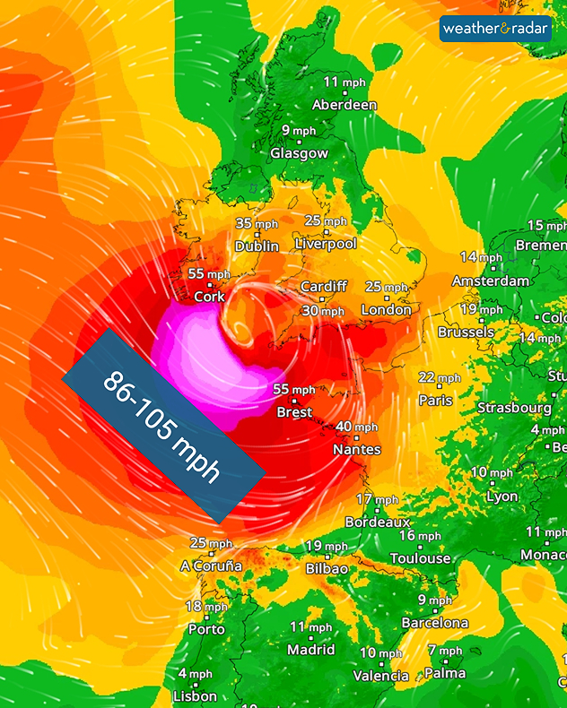
Storm Austen is set to bring severe weather from Thursday evening. Gale-force gusts and heavy rain is expected.

The storm system is currently expected to move through southern England, with gusts of up to 70 mph in the south-west, including Plymouth. The conditions will also reach western Europe, keep an eye on that if you have a holiday planned this half-term.

Trees may topple, damaging properties and vehicles. It will also cause problems for travellers: flights and ferries may be cancelled, and rail services are likely to be disrupted.

WindRadar: Severe gale-force winds are forecast over the Atlantic on Thursday evening.

The change begins on Thursday evening, with stormy weather stretching from Ireland, through the UK, into Brittany. Northern Spain will also feel the effects of the storm. On Friday, it will mainly affect the UK, the English Channel and northern France.

In isolated cases, hurricane-force gusts of around 95 miles per hour are even possible. Rainfall accumulations of 20 to 30 mm are also expected widely. Weather warnings for wind and rain are already live.

Severe weather warnings are activeread more
Weather & Radar editorial team

More on the topic

Foggy mornings and crisp autumn days. Your weather - Your shots. . . Sunday, 8 November 2026
Sunday, 8 November 2026

Your weather - Your shots

Foggy mornings and crisp autumn days
Front brings showers from the south-west. Brolly needed for some. . . Tuesday, 10 November 2026
Weather map showing blue rain bands across southern Ireland, Wales and southwest England, with a northeastward arrow and temperatures of 7–10°C.
Tuesday, 10 November 2026

Brolly needed for some

Front brings showers from the south-west
Further fog disruption expected. Growing dense overnight. . . Monday, 9 November 2026
Weather map showing widespread fog across the English Midlands, with a red fog warning symbol near Nottingham and temperatures of 4–6°C.
Monday, 9 November 2026

Growing dense overnight

Further fog disruption expected
All weather news

This might also interest you

Long-term trends need a pinch of salt. 40 °C in July?. . . Tuesday, 30 June 2026
Temperature radar of 2022 heatwave where the all-time temperature record in the UK was set. Warning symbol overlain.
Tuesday, 30 June 2026

40 °C in July?

Long-term trends need a pinch of salt
Storm Chandra makes impact. Severe gales & heavy rain. . . Tuesday, 27 January 2026
Split image showing strong winds over the UK on a forecast map and widespread rain and snow on a weather radar map.
Tuesday, 27 January 2026

Severe gales & heavy rain

Storm Chandra makes impact
Flooding, gales, and heavy snow. Storm Chandra. . . Tuesday, 27 January 2026
Split image showing aerial flooding in a town with muddy water covering roads on the left, and a rural road on the right blocked by heavy snowfall with vans stopped and a person walking in snow.
Tuesday, 27 January 2026

Storm Chandra

Flooding, gales, and heavy snow
All articles
Weather & Radar

Weather & Radar is also available on

Google Play StoreApp Store

Company

Contact us Privacy Policy Legal info Accessibility statement

Services

Uploader

Socials

facebooktwittertikToklinkList