Home
Weather London
WeatherRadar
RainfallRadar
TemperatureRadar
WindRadar
LightningRadar
Weather News
Editor's Pick
Discover the app
Weather widget
Contact us
Apps
Career
    Home / Editor's Pick /

    First Atlantic hurricane: Storm threatens US coast

11:00
8 October 2026

First storm of the season
Hurricane threatens the US coast

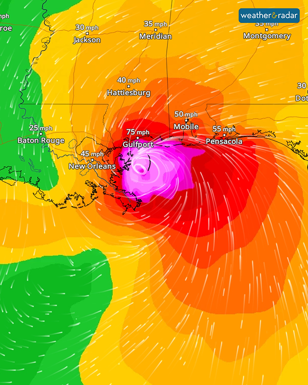
The Atlantic hurricane season, which has been relatively quiet so far, is now picking up pace. Hurricane Isaias has formed in the Gulf of Mexico. It is currently situated around 250 kilometres north of the Mexican coast and is heading towards the United States.

A hurricane warning is already in place for the coasts of Mississippi, Alabama, and north-west Florida. As things stand, Isaias is expected to make landfall in this region on Friday evening (local time) as a major hurricane.

The WindRadar forecast for Saturday night shows Isaias just east of New Orleans.

There is then a risk of gale-force winds, heavy downpours, and severe flooding. There may also be significant disruption to road and air travel.

It took more than four months after the start of the Atlantic hurricane season for Isaias to form, narrowly missing a 121-year-old record. According to the US National Weather Service, the latest first hurricane of a season on record occurred in 1905 – on October 8th that year.

Weather & Radar editorial team

More on the topic

Storm Austen approaches. What to expect tonight. . . Thursday, 22 October 2026
Split image showing a wind map with 65 mph near Brest and a swirling storm south of England, beside a man wearing glasses and holding a microphone.
Thursday, 22 October 2026

What to expect tonight

Storm Austen approaches
Preparing for the storms. What to do now. . . Thursday, 22 October 2026
Split image showing Storm Austen winds up to 65 mph near Brest and 55 mph near Plymouth, alongside fallen tree branches on a cordoned-off park path.
Thursday, 22 October 2026

What to do now

Preparing for the storms
Warnings live across the UK and Ireland. How do they work?. . . Tuesday, 20 October 2026
Weather warning map showing yellow and orange wind alerts across Ireland and England, with red level 3 areas in southwest England and a windsock symbol.
Tuesday, 20 October 2026

How do they work?

Warnings live across the UK and Ireland
All weather news

This might also interest you

A stormy week in the skies above. Your weather - Your shots. . . Sunday, 30 August 2026
Split image showing lightning branching beneath dark storm clouds above rooftops on the left and an orange-pink sunset over a calm sea on the right.
Sunday, 30 August 2026

Your weather - Your shots

A stormy week in the skies above
Long-term trends need a pinch of salt. 40 °C in July?. . . Tuesday, 30 June 2026
Temperature radar of 2022 heatwave where the all-time temperature record in the UK was set. Warning symbol overlain.
Tuesday, 30 June 2026

40 °C in July?

Long-term trends need a pinch of salt
A frozen start to the weekend. Icy conditions. . . Friday, 13 February 2026
UK temperature map dated 14.02 showing widespread subzero values in blue shading, with readings such as −4 in Glasgow, −3 in Dublin, and −2 in London, alongside a blue thermometer icon.
Friday, 13 February 2026

Icy conditions

A frozen start to the weekend
All articles
Weather & Radar

Weather & Radar is also available on

Google Play StoreApp Store

Company

Contact us Privacy Policy Legal info Accessibility statement

Services

Uploader

Socials

facebooktwittertikToklinkList